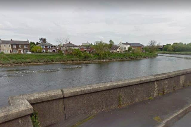
Call for 'bland and brutalist' new River Ribble flood defence walls to be redesigned
and live on Freeview channel 276
The authority’s development control committee has given the go ahead to the first phases of the £49m project, which has already seen hundreds of largely low-grade trees removed from the banks of the river.
That means construction work can now begin on the defences themselves, but County Hall will first have to approve the materials that will be used as part of the long-planned Environment Agency project, which will initially focus on two areas to the south of Preston city centre on the north and south sides of the Ribble.


Advertisement
Hide AdAdvertisement
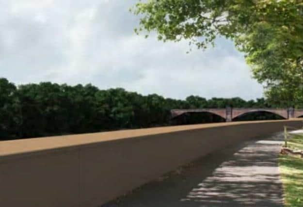
Hide AdAccording to papers presented to the committee, the Lancashire County Landscape Service has “strongly recommended” a redesign – describing indicative drawings of the proposed structures as a “retrograde step” compared to the defences currently in place.
“The pre-cast concrete walls would have a very simple, almost ‘brutalist’ appearance, which is not appropriate for the area’s local landscape character,” the report notes.
“The dominant building material in the locality is brick and structures…within the river channel are constructed of stone. No reference is made to these materials or local architectural features in the proposed flood wall.
“This, in combination with the bland and monotonous single material and surface finish only [being] broken by very widely-spaced but matching pillars, would ensure that the new walls appeared as stark, incongruous structures – especially once the concrete has become aged and weathered.”
Advertisement
Hide AdAdvertisement
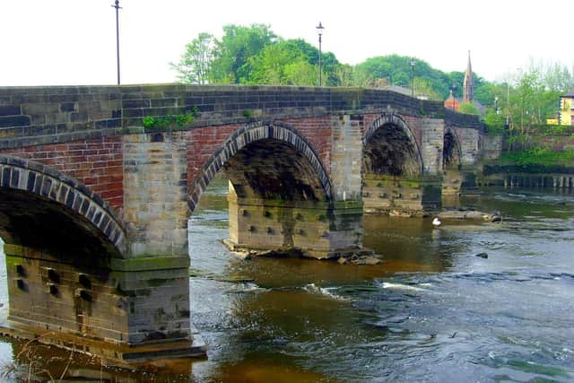
Hide AdThe damning assessment acknowledged that glass panels to be placed atop the highest walls to maintain views of the river were a welcome addition. But it concluded that the “generic” defences would nevertheless detract from the character of the local landscape and spoil the setting of features such as Penwortham Old Bridge.
However, Historic England has not objected to the proposals and a heritage statement accompanying the application concluded that the impact on the assets such as the Avenham Conservation Area, the viaduct over the River Ribble Penwortham Old Bridge and Miller Park would be “slight to neutral”.
The Environment Agency was approached for comment after the meeting, but declined to comment. Its dedicated project website notes that the appearance of the walls has not yet been finalised and adds: “By default, our designs will be sympathetic to the character of local areas and, through good design, we hope [will] improve the look and feel of the riverside environment.”
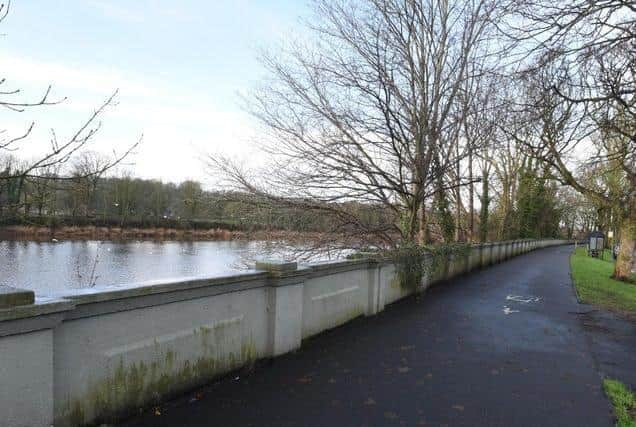
The walls that currently protect parts of Preston and South Ribble from flooding are up to a century old in parts, with the most recent upgrades having been made in the 1980s. They are now considered to be coming to the end of their life.
Advertisement
Hide AdAdvertisement
Hide AdThe new defences – which will take between three and five years to complete – are intended to better protect almost 5,000 residential properties and 350 businesses. The likelihood of climate change increasing flooding has been factored in to the design of the scheme.
The aesthetics of the walls were not not discussed by committee members, with the debate instead focussing on the potential risk of people walking along the top of them.
Preston Central West county councillor Carl Crompton told the meeting that the lower structures, which are not topped off with glass panels, would be “perfect” for that diversionary, but potentially dangerous, activity.
“You can see people walking along the walls, definitely – so whether they round it off a bit or something like that, there needs to be some…thought put in to stop people even attempting to [do that].”
Advertisement
Hide AdAdvertisement
Hide AdHowever, Rob Hope, the County Hall development control officer dealing with the proposal, warned that any such changes were likely to require an entirely new application. He also said that adding the glass viewing points to all sections of the defences would make them financially unviable.
“I don’t think you could really resolve [the risk of people walking on the defences] in a way that wouldn’t be of detriment to the visual aspect of the walls. Personally, I don’t think it would be a particular problem,” Mr. Hope added.
The meeting also heard that the defences were not designed to reduce flooding in Avenham Park, particularly in the vicinity of the pavilion, which is part of the natural flood plain. Menawhile, defences are not planned for the Leyland Road area downstream of Penwortham Old Bridge, because there are few “sensitive” properties in the area and the work was not deemed financially viable, Mr. Hope told the committee.
However, the chair of Penwortham Allotments and Gardens Association, expressed concern that the scheme might actually increase the risk of flooding in the Penwortham Holme area.
Advertisement
Hide AdAdvertisement
Hide AdJulian Edwards said it was understandable that the allotments were a “low priority”, but deserved protection where possible. He said that the depth of the foundations of a planned wall between the allotments and Penwortham Methodist Church would cause “drainage and usability issues” with the plots.
“The flood defence work [will] mean that the river downstream of the Penwortham Old Bridge will flow faster or higher. The 2019 flood event would ironically have been worse,” Mr. Edwards said.
However, Jonathan Croft, senior flood risk manager for the Environment Agency, said that the river had been assessed using a state-of-the-art systems which showed that any increase in flood risk in the area would come from “climate change alone” and would not be worsened by the defence scheme itself.
Mr. Croft said that a dozen community events had been staged and newsletters distributed, with feedback being used to gauge public opinion.
Advertisement
Hide AdAdvertisement
Hide Ad“We have continued to liaise and I think it’s demonstrated that we have done as much as we can,” he added.
The application was supported by a majority of committee members, after the county council’s planning officers recommended that it be approved – subject to conditions including that requiring final confirmation of its appearance.
“The applicant has provided a substantial volume of supporting documentation and environmental assessments to seek to demonstrate that the proposal would deliver long-term improvements in flood protection for large areas of at risk sensitive properties, while generating no measurable increased risk of flooding elsewhere,” a report to the committee noted.
The Environment Agency has committed to planting five trees for every one lost as a result of the scheme.
DISRUPTION DURING WORKS
Advertisement
Hide AdAdvertisement
Hide AdWhen construction gets under way, access through to Miller Park from Riverside and South Meadow Street will be closed and a diversion route put in place using the park entrance off West Cliff.
Meanwhile, Sport England has requested a mitigation strategy for the temporary loss of sports pitches during construction work and to provide for the safe operation of retained sporting facilities at the BAC/ EE Preston Social and Sports Association and Preston Sports Club.
FLOOD DEFENCE DETAILS
These are the proposed Environment Agency schemes that have been approved by Lancashire County Council, totalling 2km out of an overall 9km project:
Area 1 is located on the north bank of the River Ribble, to the south of Preston City centre. It is approximately 1.2km long, extending from Liverpool Road Bridge upstream to the West Coast Mainline railway bridge (WCML).
Area 1A
Advertisement
Hide AdAdvertisement
Hide AdReplacement of the existing riverside concrete wall (up to 1.2m high), with a 1.4m-1.5m high new concrete wall, between Liverpool Road bridge and Penwortham Old Bridge.
Area 1B
Replacement of the existing concrete wall (up to 1m high) with a new concrete wall with glass panels on top up to 2m total height, along Riverside between Penwortham Old Bridge and Miller Gardens Apartments.
A new 1.35m high steel flood gate located in front of Miller Gardens apartments.
A new 1.4m high concrete wall along the boundary of the BAC/EE Preston Social and Sports Association cricket pitch between Miller Gardens Apartments and Ribble Cottage.
Advertisement
Hide AdAdvertisement
Hide AdA new 1.35m high steel flood gate located adjacent to Ribble Cottage.
Replacement of the existing concrete wall (1m high) with a new concrete wall with glass panels on top up to 2.3m high, running on the river side of the road between Ribble Cottage and the railway viaduct.
Three lengths of the existing riverbank from just downstream of Old Penwortham Bridge to the WCML will be stabilised.
Area 1C
A concrete wall up to 1.9m high and two flood gates (1.4m high and 1.8m high) adjacent to the western end of the WCML railway bridge.
Area 1D
Advertisement
Hide AdAdvertisement
Hide AdNew access gates, slipway, resurfacing works and footpath/cycleway realignment at the Sea Cadets.
Area 2 is located on the south bank of the River Ribble, to the south of Preston city centre. This area is approximately 0.8km long,
Area 2A
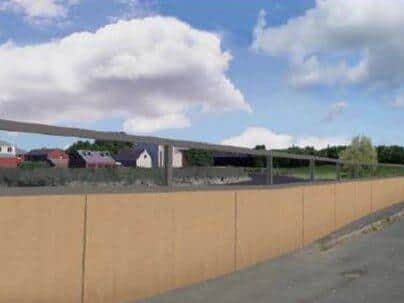
A new concrete wall totalling 174m in length and up to 2.47m high to the west and south of the Penwortham Methodist Church, running along the allotment boundary and tying into the old railway embankment. Inclusion of iron railings adjacent to allotment boundary to maintain 1.8m high security;
Road-raising at the entrance to Penwortham Methodist Church.
Advertisement
Hide AdAdvertisement
Hide AdGround-raising along the footpath that cuts through the disused railway embankment into Penwortham Residential Park.
Area 2B
Replacement of the existing concrete wall with a new concrete wall with glass panels on top up to a total height of 2.2m, along Riverside Road extending upstream from the Cadent Gas Pipe Bridge.
New 1.5m-high concrete wall along the riverfront linking Riverside Road to Ribble Sidings. A retaining wall and inclined embankment will be constructed to stabilise the existing bank; and
A 3.5m-high earth embankment along the river front of Ribble Sidings, replacing the existing 1.7m high embankment.
Area 2C
Advertisement
Hide AdAdvertisement
Hide AdFilling in a culvert with concrete under the WCML, approximately 500m inland from the River Ribble.
Ecological and landscape enhancements at Ribble Sidings.
Source: Lancashire County Council development control report
Comment Guidelines
National World encourages reader discussion on our stories. User feedback, insights and back-and-forth exchanges add a rich layer of context to reporting. Please review our Community Guidelines before commenting.