First images of what £49m flood defence scheme for Preston and South Ribble could look like
and live on Freeview channel 276
The Environment Agency has finalised a blueprint for the £49m Preston and South Ribble Flood Risk Management Scheme, which is now going through the planning permission process.
Flood defences already in place were built at various points between the 1920s and 1980s, and are said to be “coming to the end of their life”.
Advertisement
Hide AdAdvertisement
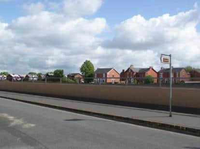
Hide AdAs well as replacing old and decaying flood defences with taller and more modern materials, new walls are set to be built along the boundary of the BAC/EE Preston Social and Sports Association cricket pitch between Miller Gardens Apartments and Ribble Cottage, on the footpath to Golden Way, and outside Penwortham Methodist Church.

Glass panels will be installed in three of the new and replacement walls in the area. There will be 80cm-high glass panels on top of concrete walls between Penwortham Old Bridge and Miller Gardens Apartments, on a concrete wall on the riverside in front of the Continental pub, and a 60-80cm tall glass panel running on top of a replacement concrete wall running along Riverside Road from the Cadent Gas Pipe Bridge to Stanley Avenue.
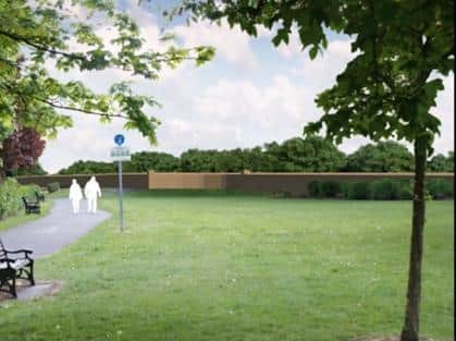
There are also ambitious plans to create 'Ribble Sidings' - a variety of new wetland habitats created within a new network of footpaths along the South Ribble side of the River Ribble.
A decision on the planning permission is expected within weeks, and should the plans get the go-ahead, work is expected to start next year, to be completed in 2024.
Advertisement
Hide AdAdvertisement
Hide AdA spokesman for the Environment Agency said: "We will be working to remove, replace and repair 9km of flood defences in total, we are working with partners to minimise disruption.
"The project will be constructed starting in 2021 and ending in 2024. During this time our communities should expect disruption in the form of road closures, construction works, footpath and cycle route diversions, increased noise and the increased presence of contractors."
Rev Janet Titterton of Penwortham Methodist Church said that a team from the church were in dialogue with the Environment Agency about the work, and that while concerns had been raised over access to the church during construction, details about how the church would be affected were still unclear.
The work is being split into five phases:
Area1: Broadgate and Riversway
Area 2: Lower Penwortham
Area 3: Frenchwood and Fishwick Bottoms
Area 4: Walton-Le-Dale (along the Capitol Centre)
Area 5: Higher Walton and Samlesbury
The Environment Agency's preferred detailed design for later phases are still ongoing and approval for later phases of the scheme will be submitted in spring 2021.
Advertisement
Hide AdAdvertisement
Hide AdResidents are also warned that a number of trees will have to be removed to facilitate the work and ensure the flood defences have a long life.
The Environment Agency is committed to planting five trees for every tree that has been removed. The areas for replanting are starting to be identified and the trees will range from saplings to more mature trees.
What is being proposed for areas 1 and 2?
BROADGATE: Replacement of the existing concrete wall, with a new concrete wall, between Liverpool Road bridge and Penwortham Old Bridge. Existing Wall Height: 0.75 - 1.23m Proposed Wall Height: 1.20 – 1.6
RIVERSIDE: A new concrete wall along the boundary of the BAC/EE Preston Social and Sports Association cricket pitch between Miller Gardens Apartments and Ribble Cottage (the two flood gates). Existing Wall Height: 0. Proposed Wall Height: 1.16 – 1.22m
Advertisement
Hide AdAdvertisement
Hide AdRIVERSIDE: Replacement of the existing concrete wall, with a new concrete wall with glass panels on top, along Riverside highway between Penwortham Old Bridge and Miller Gardens Apartments. Existing Wall Height: 0.78 - 1.08m. Proposed Wall Height: 1.63 – 2.24m (incl. 800mm high glass panel)
RIVERSIDE: Replacement of the existing concrete wall, with a new concrete wall with glass panels on top, running on the river side of the road in front of the Continental Public House restaurant. Existing Wall Height: 0.90 - 1.09m. Proposed Wall Height: 1.78 – 2.53m (incl. 800mm high glass panel)
RIVERSIDE ROAD: Proposed replacement of the concrete flood defence wall, with precast concrete flood defence wall and glass panels on top, running along Riverside Road from the Cadent Gas Pipe Bridge to Stanley Ave (upstream end of Riverside Road). Existing Wall Height: 1.00 - 1.30m. Proposed solid Wall height: 1.70 - 2.20m (incl. 600-800mm glass panel on top)
RIBBLE SIDINGS: Proposed replacement of the 1.7m flood defence embankment at Ribble Sidings with 3.5m high flood defence embankment with a 3m crest width.
Advertisement
Hide AdAdvertisement
Hide AdThe existing riverside footpath (bridleway) route will be maintained with an access ramp over the proposed flood defences. A new habitat area will be created on the dry side of the flood defence embankment.
The design includes dipping platforms which will allow people to interact with the new habitat. As the scheme progresses, these plans will form part of our public engagement
MILLER PARK: A new concrete retaining wall along a ramped section of the main cycleway and earth embankment in Miller Park. Existing Wall Height: 1.09m. Proposed Wall Height: 1.90 – 2.00m
PENWORTHAM METHODIST CHURCH: A new proposed pre-cast concrete flood defence wall between 0.65-2.2m tall.
Advertisement
Hide AdAdvertisement
Hide AdThere is also a proposed road ramp to raise existing road levels at the entrance to Penwortham Methodist Church. The private access road into the church and the adjacent allotments will be raised by approximately 1m.
There are also plans to partially infill the Network Rail disused underpass near the church with 1.5m high solid concrete wall.
GOLDEN WAY FOOTPATH: Proposed pre-cast concrete flood defence wall between 0.65-2.2m tall
The Environment Agency is updating its online engagement platform for the duration of the project. This can be seen here: http://www.thefloodhub.co.uk/psr
Comment Guidelines
National World encourages reader discussion on our stories. User feedback, insights and back-and-forth exchanges add a rich layer of context to reporting. Please review our Community Guidelines before commenting.