Weekend walk: Haslingden Grane


Most routes from Clough Head tend to go east involving a circuit of the two reservoirs in the Grane Valley. Here’s a route less travelled by going west.
WALK FACTS
Start: Clough Head Café and Information Centre BB4 4AT
Distance: 6 ½ miles
Time: 3 ½ – 4 ½ hours
Grade: Moderate. There is a long descent to Hoddleston balanced by a long climb back to the start which means this averages out as moderate. The route is interspersed with stiles and fields with livestock.
Map: OS Explorer 287 The West Pennine Moors
DIRECTIONS
Advertisement
Hide AdAdvertisement
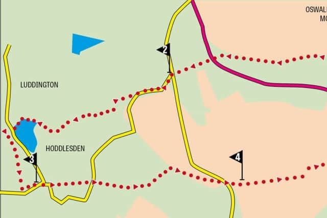
Hide Ad1.To the left and rear of the café go through a kissing gate leading onto a path through a stand of trees out onto the open moor. There follows a short steep climb to intercept the Rossendale Way close to kissing gate and a sign post adorned with so many waymarks it looks like badges on a cub scout’s arm. Go through the kissing gate and keep the path for just under a mile. Where the Rossendale Way goes left keep ahead on a less used path passing a second conifer plantation. After a stile next to a wall bear left at the wall end to drop to the Grane Road close to the boundary between Rossendale and Blackburn & Darwen. On the far side of the road locate a stile leading into rough pasture. The path – for what it is – descends for ¼ to a road close to a junction. Cross onto the lane leading downhill and unsuitable for HGVs, cross a bridge and climb to the top of the rise. Here where the road bends left keep ahead through a wooden gate following a path down to a cluster of properties that form part of Pickup Bank.
2. Passing in front of Top o’ th’ Coppy Farm turn right onto a farm drive leading down to fields. Go through a gate onto an enclosed path between paddocks. As the way levels out cross a stile and bear left into the adjoining field. At a wall corner on the right turn right to a gate on the right. Through this cross to the far corner where a stile puts you onto the embankment of Johnson Reservoir home of the Darwen Loyal Angling Club. (This rather begs the question whether there is a disloyal angling club). Follow the shores of the reservoir to the members’ car park and turn right onto a lane in front of a cemetery. At the end of the cemetery wall turn left onto a wide track and as you reach a junction turn left past chicken sheds into a meadow. Follow the field edge to the far corner where a gap places you on a drive at the cemetery’s rear entrance. Turn right and follow the drive to reach Baynes Street close to a primary school. Keep ahead to arrive in the centre of Hoddlesden opposite the Ranken Arms.
3. The war memorial in Queen’s Square is well worth studying. Above each panel of the commemorated names are decorative representations of the three armed services plus the military ambulance service. Now is the time to gird one’s loins for having descended 500ft to get here you have to march back (or amble if you prefer) to the top of the hill. With the memorial on your left walk down Queen Street to where it becomes Long Hey Lane and leaves the village. Just past a bus turning lay-by turn left onto a public footpath that follows a drive towards a substantial property. Just before the gardens branch left to cross a stile by a metal gate. Keep ahead across fields to return to Long Hey Lane between two properties. Cross to the drive of Lark Hill farm and after passing through its yard cross a stile on the left just before the track meets a field boundary. Bearing left from the track descend to a wooden footbridge on a barely discernible path. Across the brook the path is even less discernible but as you climb away from the bridge bear slightly right to reach a stile in a fence. Over this follow the hedge on the right to a stile at a junction of footpath. Here once over turn immediately left to follow an enclosed overgrown path up the hill that joins a track between two properties. Turn right. Follow the track past Height End Farm and continue bearing left at a fork to arrive on Broadhead Road.
4. Now comes the payoff for all the effort of getting here – a superb moorland yomp taking you down to Haslingden Grane. Turn right on the road and then left across a stile next to a padlocked metal gate to join a track (boggy at first). Keep on this past a solitary gatepost (or maybe a standing stone.) In a little after half a mile a wooden gate signals the descent to Calf Hey Reservoir. On reaching pasture as opposed to moorland drop down near a gully aiming to the right of a ruined farm. Here re-join the Rossendale Way. Turn right. Keep on the path as it edges along a dense conifer plantation and then enters it. Keep left at a metal footpath sign to descend to a path junction. Where the Rossendale Way heads right go left. This path will bring you to the tip of Calf Hey Reservoir. Across the bridge turn right on a service road. Keep on this to reach a car park. Just after the car park turn left on a footpath that leads back to Clough Head keeping left at a road bend.
- Walk checked by the Lancashire Dotcom Walkers.