Yellow weather warning for ice issued by Met Office as temperatures set to plunge following overnight snowfall
and live on Freeview channel 276
The forecaster warned “ice is likely to be a hazard where snow has fallen overnight”.
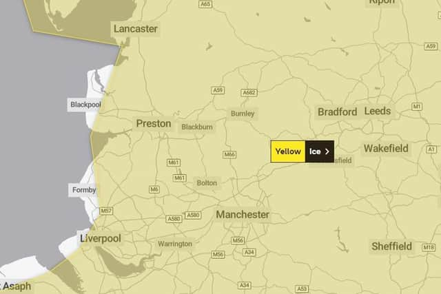
A yellow weather warning for ice which covers most of the county was subsequently issued by the Met Office.
Advertisement
Hide AdAdvertisement
Hide AdIt came into effect at 9.30am on Friday morning (March 10) and is set to end at 10am on Saturday (March 11).
The UK Health Security Agency has also issued a level 3 cold weather alert for the whole of England.
Dr Agostinho Sousa, Head of Extreme Events and Health Protection at the UK Health Security Agency, said: “During periods like this, it is important to check in on family, friends and relatives who may be more vulnerable to the cold weather, as it can have a serious impact on health.
“If you have a pre-existing medical condition or are over the age of 65, it is important to try and heat your home to at least 18°C if you can.’’
Advertisement
Hide AdAdvertisement
Hide Ad

What has the Met Office said?
“Whilst falling snow will clear from the south and east of the warning area in the next few hours, lying snow and ice will likely continue to be a hazard through the rest of this morning,” a spokesman for
“Icy stretches should become confined to higher ground this afternoon, before temperatures fall below freezing widely this evening.
“This will lead to untreated surfaces left wet by snow melt becoming icy at all levels, with some disruption to travel likely.”

What should I expect to see?
- Possible travel delays on roads stranding some vehicles and passengers
- Possible delays or cancellations to air travel
Advertisement
Hide AdAdvertisement
Hide Ad
- Bus and train services may be delayed or cancelled, with some road closures and longer journey times possible
- Untreated pavements and cycle paths might be impassable
- A chance of injuries from slips and falls on icy surfaces
- There is a small chance that power cuts will occur and other services, such as mobile phone coverage, may be affected
Will we see anymore snow?

The warning covers large swathes of the county will be in valid from 3pm on Saturday (March 11) until 6am on Sunday (March 12).
Advertisement
Hide AdAdvertisement
Hide AdThe warning does not cover Blackpool, Fleetwood or Lancaster.
Accumulations are likely to be confined to elevations above 200m, with 2-5cm possible.
5-10cm is possible above 400m.
Here is the latest Met Office five-day forecast for the region:
Today:
Overnight rain, sleet, and snow gradually clears through the morning leaving a much drier and brighter afternoon though still the odd snow flurry is possible. Strong winds to start but these gradually easing. A chilly day, particularly in the wind. Maximum temperature 6 °C.
Tonight:
A fine evening with clear skies. This means temperatures will drop quickly overnight leading to a widespread sharp frost with icy stretches likely. Light winds. Minimum temperature -3 °C.
Saturday, March 11:
Advertisement
Hide AdAdvertisement
Hide AdA cold and frosty start with bright skies. Staying largely dry and bright through the day with a band of rain, sleet and snow later alongside strengthening winds. Staying cold. Maximum temperature 7 °C.
Outlook for Sunday (March 12) to Tuesday (March 14):
Cold again on Sunday with patchy cloud and rain arriving later. Patchy rain on Monday though turning milder. Remaining unsettled into next week with strong winds on Monday and Tuesday.