Storm Debi: Live weather, travel and flooding updates as Met Office warns of 60mph winds
and live on Freeview channel 276
The Met Office has issued amber and yellow weather warnings ahead of Storm Debi hitting Lancashire on Monday (November 13).
We'll be bringing you all the latest weather, travel and flooding updates right here as Storm Debi passes through the region.
Storm Debi - live updates as 'strong and disruptive' winds forecast on Monday
Key Events
- Amber and yellow warning are in place throughout the day
Update on Blackpool trams
Blackpool Transport have now confirmed that ALL tram services will be off for the rest of the evening.
Weather warning in Lancashire extended
The amber level warning for wind has been extended: originally due to end at 4:00pm, it is now in place until 9:00pm.
Meanwhile, the amber level warning for rain was extended from 4:00pm until 6:00pm but has now ended.
Read more on the Met's website: https://www.metoffice.gov.uk/weather/warnings-and-advice/uk-warnings#?date=2023-11-13&id=0927f461-b5cc-4bbf-8f64-04383cf830f2
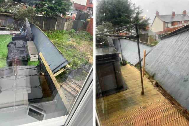
Leaf blowers?? In a storm??
Pictured is a Places for People ground workers out in Preston with a leaf blower earlier today (November 13).
We hope he realised the futility sooner rather than later!


Severe travel disruption as all trains in and out of Preston cancelled or delayed

All trains running through Preston station are continuing to be cancelled or delayed by up to 45 minutes due to severe weather. Full story: https://www.lep.co.uk/news/transport/storm-debi-severe-travel-disruption-as-all-trains-in-and-out-of-preston-cancelled-or-delayed-4408299
Tram disruption
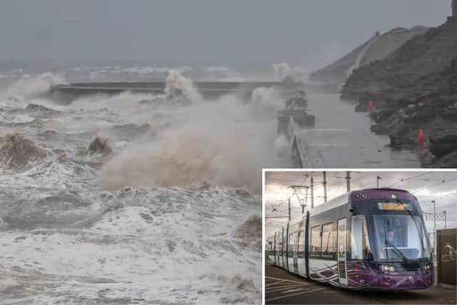
All trams south of North Pier have been cancelled due to the severe weather. Read more: https://www.blackpoolgazette.co.uk/news/transport/blackpool-transport-all-trams-south-of-north-pier-cancelled-due-to-storm-debi-4408021
Today's hour-by-hour storm forecast
Met Office forecast: “A spell of very strong westerly winds is expected to develop later Monday morning across northwest England in association with Storm Debi.
"Inland gusts of 60-65 mph are likely in places whilst along the coast gusts of 70-80 mph are expected. Winds will gradually ease into the evening.”
Hour-by-hour
9am – 10% chance of rain, 11°, wind gusts 34mph
10am – 10% chance of rain, 11°, wind gusts 43mph
11am – 80% chance of rain, 10°, wind gusts 48mph
12pm – 80% chance of rain, 10°, wind gusts 54mph
1pm – 50% chance of rain, 11°, wind gusts 58mph
2pm – 60% chance of rain, 11°, wind gusts 62mph
3pm – 80% chance of rain, 11°, wind gusts 56mph
4pm – 10% chance of rain, 11°, wind gusts 52mph
5pm – 10% chance of rain, 11°, wind gusts 46mph
6pm – 10% chance of rain, 11°, wind gusts 39mph
7pm – 30% chance of rain, 11°, wind gusts 37mph
8pm – 10% chance of rain, 11°, wind gusts 33mph
9pm – 60% chance of rain, 11°, wind gusts 30mph
10pm – 60% chance of rain, 11°, wind gusts 29mph
11pm – 60% chance of rain, 11°, wind gusts 29mph
Video: Storm Debi arrives in Blackpool
These are the scenes on Blackpool's seafront as Storm Debi lashes the Fylde Coast with gale-force winds and heavy rain today.
Seven flood alerts issued for Lancashire
Parts of Lancashire could be hit by flash flooding today (November 13) as heavy downpours hit the county.
It comes after the Met Office issued a yellow weather warning for rain and an amber warning for wind.
Here are all the flood alerts issued by the Environment Agency
Coast from Fleetwood to Blackpool Areas most at risk include Fleetwood, Larkholme, Broadwater, Cleveleys, Rossall Beach, Anchorsholme, Blackpool and Revoe.
Highest tide level is expected to be at Fleetwood, Larkholme, Broadwater, Cleveleys, Rossall Beach, Anchorsholme, Blackpool and Revoe at 10:45 AM on 13/11/2023. Flooding is possible two hours either side of this time.
Wyre estuary from Fleetwood and Knott End to Little Eccleston
Areas most at risk include Tiger's Tail, Wyre Dock, Burrow's Marsh, Burn Naze, Thornton, Trunnah, Stanah, Poulton-le-Fylde, Skippool, Hambleton, Cold Row, Little Singleton, Little Eccleston and Crow Woods.
Highest tide level is expected to be at Tiger's Tail, Wyre Dock, Burrow's Marsh, Burn Naze, Thornton, Trunnah, Stanah, Poulton-le-Fylde, Skippool, Hambleton, Cold Row, Little Singleton, Little Eccleston and Crow Woods at 10:45 AM on 13/11/2023. Flooding is possible two hours either side of this time.
Coast at North Morecambe Bay Flooding is possible at Coast at North Morecambe Bay from Roosebeck to Carnforth including low lying areas around Ulverston, Greenodd, Haverthwaite, Flookburgh, Grange-over-Sands, Levens, Milnthorpe, Sandside, Arnside and Silverdale between 08:45 AM and 12:45 PM on 13/11/2023.
Coast from Heysham to Cockerham
Areas most at risk include Sandylands, Middleton, Sunderland, Bank Houses, Hillam, Sand Side and Cockerham Moss.
Highest tide level is expected to be at Sandylands, Middleton, Sunderland, Bank Houses, Hillam, Sand Side and Cockerham Moss at 10:45 AM on 13/11/2023. Flooding is possible two hours either side of this time.
Lune estuary south west of Lancaster
Areas most at risk include Aldcliffe Marsh, Heaton Marsh, Marsh, Greyhound Bridge, Skerton Bridge, Newton, Overton, Middleton, Glasson and Thurnham Moss.
Highest tide level is expected to be at Aldcliffe Marsh, Heaton Marsh, Marsh, Greyhound Bridge, Skerton Bridge, Newton, Overton, Middleton, Glasson and Thurnham Moss at 10:45 AM on 13/11/2023. Flooding is possible two hours either side of this time.
Rivers Brathay, Rothay and Winster
Flood alert area: Rivers Brathay, Rothay and Winster and other watercourses, from Grasmere to Grange-over-Sands including low lying areas around Ambleside, Skelwith Bridge, Windermere, Hawkshead, Newby Bridge, Backbarrow, Cark and Cartmel.
Rivers Duddon, Crake and Mill Beck
River levels have risen on the Rivers Duddon, Crake and Mill Beck due to Storm Debi.
Flooding is possible at Rivers Duddon, Crake and Mill Beck and other watercourses, from Coniston to Barrow-in-Furness including low lying areas around Ulpha, Duddon Bridge, Broughton in Furness, Kirkby-in-Furness, Dalton in Furness and Ulverston from 07:45 AM on 13/11/2023.
New weather warning for heavy rain
The Met Office has issued yet another weather warning covering all of Lancashire, this time for rain.
The third alert, a yellow warning, is on top of the amber wind warnings already issued. According to forecasters, the latest alert comes into force at 11am today (November 13) and lasts until 6pm tonight.
Forecasters say: "Heavy rain associated with the passage of Storm Debi will cause some local disruption."
Comment Guidelines
National World encourages reader discussion on our stories. User feedback, insights and back-and-forth exchanges add a rich layer of context to reporting. Please review our Community Guidelines before commenting.