Weekend walk: Widdop


All in all this is a pretty wild walk in the border country of the South Pennines. It is a landscape of sweeping moors littered with outcrops of millstone grit eroded into weird forms by the action of wind, water and ice.
WALK FACTS
Start: Widdop Reservoir car park which is in Yor…That Other Place!
Advertisement
Hide AdAdvertisement
Hide AdPostcode: HX7 7AT. This is so out of the way here is the grid reference: SD937 327
Distance: 6m 10k
Time: 3 – 4 hours
Grade: A walk in two halves. The first half is a demanding moorland walk. As for footpath think of Mr Spock! (“It is a footpath Jim, but not as we know it!”) Suffice to state where they exist they are not always clear. The second half especially after the descent from Lad Law is as easy as pie!
Map: OS OL 21 South Pennines.
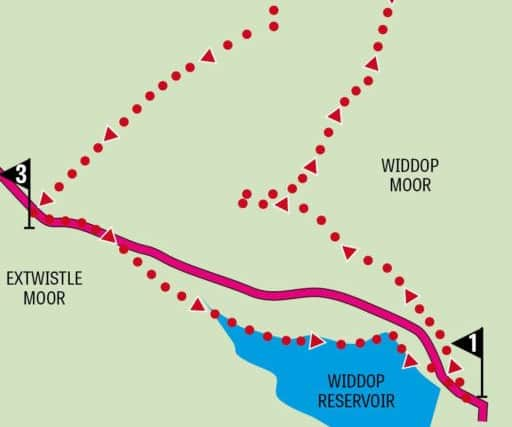
DIRECTIONS
1.From the car park turn left towards the reservoir, cross the road obliquely right just after a stone rampart of a bridge and find a way upwards through the tussocky grass and heather onto the edge of the moor. The idea being that once you reach the edge (you’ll know it when you see it) bear left and follow it, roughly parallel to Widdop Reservoir, towards a prominent high point on the skyline (Grey Stone Hill). On the way you will encounter a number of rock outcrops. Grey Stone Hill is a fine view point especially looking westwards towards the Thursden valley and Pendle Hill. The route now turns north westwards (right) to a large outcrop called Dove Stones a little under a mile away. It is a tough mile for there isn’t much in the way of a path. This where those of you who use poles have an advantage as underfoot the ground can give way to concealed drops of the knee twisting variety as this writer can attest! This outcrop shows evidence of pre-historic human activity. The largest rock, a little way to the left of the main group, is Dove Stone. It looks nothing like a Dove. From here the route follows the contour round to Lad Law. If the prospect of forcing your way through more peat and heather daunts you be of good cheer for since reaching Dove Stones you are now back in Lancashire! Dropping off from the outcrop keep ahead maintaining height to cross Warcock Hill and then swing left on a narrow and hardly defined path as the route turns towards Boulsworth Hill. Below its highest point there is a fence. Turn left when you reach it and follow it to locate a stile a little below the highest point – Lad Law (517m 1686ft) and its trig point.
2. Lad Law provides a wonderful viewing platform with a panorama encompassing a good chunk of Red and White Rose counties. From the trig point bear left, past a distinctive outcrop on the edge (the eponymous Lad Law Stones), and cross a stile. The footpath (one of the clearer ones) leads down the flank of the hill, and after crossing a stream reaches a flat, grass covered area evidently a gathering area at the end of a shooters track. From here a Landrover track leads south-westwards out to the Widdop Road, a mile away. After all the exertion over the moors you’ll appreciate this track and you’ll make good progress along it.
Advertisement
Hide AdAdvertisement
Hide Ad3. When you reach the road turn left. From the watershed the road descends pleasantly back into Calderdale with the reservoir before you. Returning to the car park you can follow the Burnley Way as it branches right a short distance past the border. After crossing a brook this route begins to climb along the fellside with a ruined wall on your left. Here you will have fine views of the reservoir. Almost a mile from the road it meets the downward track that is now part of the Pennine Bridleway. Turn left and walk downhill to the end of the reservoir close to a utility building clearly inspired by Egyptian monumental architecture. Turn left across the dam. A footpath on the right a short distance from the road will take you back to the car park. A more direct route but keeping you off the road joins a track on the right 600yds from the ‘Welcome to Calderdale’ sign and descends to a path junction. Here, go straight to pick up a path leading to a footbridge across a channel. With the reservoir on your right follow its shores to Widdop Lodge. Just after the lodge follow a drive back to the road. Turn right for the car park.
- Route devised by Malcolm McCulloch.
- Bob’s walks are now available as digital guides on the iFootpath website and App (see iFootpath.com).