Weekend walk: Rufford to Burscough


When dying King Arthur had to return the sword Excalibur he sent his knight Griflet to throw the charmed weapon into the middle of a the lake where it was received by the Lady of the Lake if the naked arm waving the sword fits her description. This is the legend but where was the lake?
Martin Mere on the West Lancashire Plain is a good candidate. Before the mid-17th century it formed the largest lake in England. As it was no great depth, in the 1600s the landowners began to drain the mere using the technology developed by the Dutch for land reclamation. This created fertile farmland so that growing has been the main activity ever since in a landscape reminiscent of the flatlands of Holland.
Advertisement
Hide AdAdvertisement
Hide AdThe Martin Mere that remains today is but a remnant of the vast lake but its significance as a waterfowl reserve gives it a value even greater than the worth of Excalibur itself. During the winter months it hosts thousands of migratory ducks, geese and swans from the Arctic Circle while year round its breeding programme ensures the survival of many rare species. In terms of wildlife it is one of the most important sites in the UK.
Walk Facts
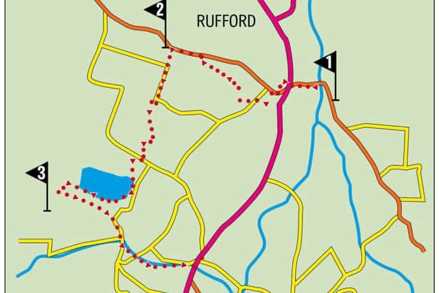
Start: Church Road, Rufford L40 1TA
Finish: Burscough centre
Distance: 8 miles
Time: 3 – 4 hours
Grade: Easy
Maps: OS Explorer 285 Southport and Chorley
Directions
1.From the church walk west along Church Road to Liverpool Road A59. Turn right and cross the road using the traffic island into Flash Lane. In the grounds of the village hall note the stone cross erected to commemorate the millennium that replaced one put there 600 years previously. Walk along Flash Lane an attractive conservation area to reach Holmeswood Road with the primary school to the left. Turn right and soon after left into Brick Kiln Lane. After 250yds turn right onto a footpath that runs alongside a drainage ditch. Follow this to reach Cousins Lane opposite the cricket club. Keep ahead on a footpath which after passing the clubhouse takes you to the edge of Mere Sands Wood, a Wildlife Trust reserve. Turn right onto the main path and follow it as brings you to the visitor centre car park. Continue on the main track a little to the right opposite and continue until you reach the signpost for Holmeswood Village. Turn right to leave the reserve at a footbridge and take the footpath to Holmeswood Road. Turn left. Owing to local dispute the public right of way leading from Sandy Lane to Sandy Way is blocked by the landowner so keep on the main road to the junction at Moss End and turn left into Sandy Way.
2. Keep on Sandy Way for a little over half a mile to where it bends left. Here go straight on following a path out onto the wide prairie of the Lancashire Plain to a footbridge across a drainage ditch. Turn right to a second bridge and then turn left in the direction of Martin Mere as indicated by a sign post. At the next sign post bear right taking a grassy path towards a large farm complex that is Tarlscough Hall. Before you reach the hall join a farm track to the right that swings round past an abandoned farmhouse and arrives on Tarlscough Lane. Turn right towards Martin Mere a Wildfowl Trust reserve. In just under 150yds turn left onto a footpath alongside the perimeter fence. Keep on the track to reach a junction with a sign post. Once a public footpath went right here crossing behind the reserve but that has been redirected. Go straight on through a gate in the direction of the reedbed walk and the Farm Tearoom (if you need to cut the walk short go left following a well signed route to Burscough Bridge). A broad path skirts the edge of extensive reedbeds which is what you would expect. On route two viewing platforms allow you to see what’s beyond the impressively tall reeds – the last remnants of the once huge lake that was here before the drainage schemes. As you reach the far side of the mere turn left at a path junction in the direction of the tearoom. The path takes you to a level crossing of the Southport – Wigan railway.
3. Cross with care and turn immediately left following a grassy path alongside the railway. Keep on it until you arrive at New Lane Station with its attractive station house. Turn right onto New Lane and walk along it to the swing bridge across the Leeds-Liverpool Canal. Just before the bridge turn left onto the towpath. Keep ahead staying on the towpath for just under a mile to reach Burscough. As you leave the canal turn left onto the busy A59 Liverpool Road. The bus stop for the 2A returning you to Rufford is opposite the Hop Vine which is recommended if you have some time to kill.
Advertisement
Hide AdAdvertisement
Hide Ad- This walk uses the hourly 2A Ormskirk – Preston bus service to return you to the starting point.
- Bob’s walks are now available as digital guides on the iFootpath website and App (see iFootpath.com).