Weekend walk: Much Hoole


In 1639 at Carr House Much Hoole the curate of St Michael’s Church Jeremiah Horrocks made the first scientific oberservation of the transit of Venus, a rare astronomical event. The last one took place in 2012 and you have to stick around to 2117 for the next one. In itself it doesn’t sound like a big deal but due to Horrock’s efforts many other scientific discoveries were made about the solar system and universe. It would be nice to think that young Jeremiah would have taken a break from his mathematical musings and clerical duties by wandering in the fields near his home. If he did he would have certainly been familiar with parts of the walk described below.
WALK FACTS
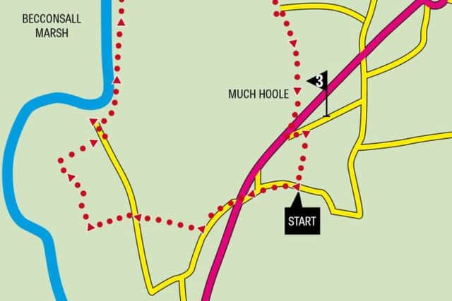
Start: Close to St Michael’s & All Angels Church Much Hoole PR4 5JQ
Distance: 4 miles
Time: 2 hours
Grade: Easy but with a number of stiles
Maps: OS Explorer 286 Blackpool & Preston
DIRECTIONS
Advertisement
Hide AdAdvertisement
Hide Ad1. From the church car park cross Liverpool Old Road turn left and almost immediately turn right onto a drive. In a short distance the drive swings right but here keep ahead to cross a stile next to a wide gate. Follow the side of a field to arrive on Haunders Lane. Turn right and then in 50yds turn left through a gap in the hedgerow to join a narrow path leading along the right side of a field. After passing through a thicket cross a plank bridge to reach a farm track. Turn right. Keep on this to reach Marsh Farm noting the closer it gets to the farm the less defined it seems to become (normally it works the other way round). After passing a green house on the left the route soon reaches the farm drive with the house and yard to the left. Turn right on the drive and follow it as it bends to the right passes Hannings Farm (marked Much Hoole Marsh House on the OS map)to reach the end of Haunders Lane. At the direction post turn left onto a path that quickly takes you onto the embankment above the River Douglas (or River Asland if you prefer!). Asland or Douglas this was a significant waterway in the early 18th century. Before the advent of canals many rivers were engineered to make them navigable to small ships. The Douglas linked the coal fields near Wigan to the Ribble and Irish Sea. Its commercial life was short in that it was superseded by the Leeds-Liverpool Canal in the 1780s. Keep on the embankment for over half a mile and then drop to a stile next to a metal gate. Keep to the fence on the left as you cross a field to a similar arrangement leading onto the bottom of Marsh Lane.
2. By now the general topographical theme of this area will be obvious with the predominance of Marsh in several place names. The route has a mere 47ft of ascent and most of that will be clambering over stiles. Turn right onto the lane and follow it past Lower Marsh Farm with its ancient brick built manor house on the right and then Marsh House Farm on the left. 140yds past this building turn right over a stile next to a metal gate. Cross the field to a stile close to an old concrete gate. Here the route crosses a disused railway line – the former Preston – Southport line. Once on the track go slightly right to locate the (obscure) stile opposite. The path continues across a large field towards a large farm complex (Ravenskerne). Cross a stile onto an enclosed path with a tall hedge to the right. Keep on this to arrive on a drive in front of a house. Turn left and then after 40yds turn right over a stile onto another enclosed path with a tall beech hedge to the right. After a plank footbridge enter a field and bear slightly left to a wooden footbridge. From here follow the path alongside a hedge across two fields. After another wooden bridge continue to a corner with a small plank bridge turn right and in a short distance go through a gap onto Liverpool Road.
3. Cross Liverpool Road – easier said than done (there is a no-traffic zone which in theory can be used as an island). Turn left into Liverpool Old Road. Keep to the right and after 100yds turn right onto a footpath with a helpful map displayed on the wall end. At first on an enclosed path cross a field and after a stile go through a metal kissing gate. Just after this cross a stile embedded in the hedgerow to the left of the main path. The path crosses to a footbridge into a large field to the rear of a property. Aim for the right side of the house. A stile next to a metal gate leads onto Town Lane. Turn right. Town Lane leads back to the A59 near San Marco’s Restaurant. Cross Liverpool Road at the traffic island to reach Liverpool Old Road. Follow this past St Michaels CofE Primary School and back to the church.
- Walk checked out by John Clare and Frank Clare.