Weekend walk: Hurst Grange Park


Happy New Year! For readers relatively new to the supremely beneficial activity of walking building up confidence to follow a route can seem somewhat daunting despite the range of hi tech aids that can be downloaded onto your smart phone. However much you can study a map or a guide there is no substitute for putting on your boots and getting out there and doing it. By far the easiest ways of developing confidence is to reverse a route you know. It is quite surprising how different the landscape can look by this simple change in direction. The walk below was published this time last year but went in a clockwise direction and is offered by way of example. May I take this opportunity to wish all my readers happy walking in 2019.
WALK FACTS
Start. Hurst Grange Park, Penwortham PR1 9BD
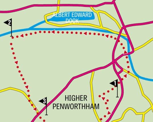
Distance: 5miles 9k
Time: 2 - 3 hours
Grade: Easy
Map: OS Explorer 286 Blackpool & Preston
DIRECTIONS
1.From the car park turn right onto Hill Road and then right again onto Valley Road. This attractive residential lane gently descends to a bridleway on the right which takes you across the A582 Golden Way and continues to Leyland Road. Cross the road, turn right and then left onto an unmade road signed for Penwortham Holme car park. Keep on this with the River Ribble on your right to reach a slope leading onto Liverpool Road. The idea now is to cross the road onto the entrance opposite but as Liverpool Road is always busy the safest way will be to go right crossing Penwortham Bridge to the traffic lights and using these to assist you. Once at the entrance go through a kissing gate to the right. Now on the Ribble Way keep ahead on a riverside drive taking you under a modern road bridge and continuing through a neatly laid out park. After an electricity utility building on the left the drive downgrades to a stony track which brings you to a metal kissing gate leading onto an embankment and an altogether different scene. It could hardly be called rural for this is a much managed landscape but it is more open and being flat has a lot of sky. After passing Penwortham Golf course on the left in ½ a mile the entrance to Preston Dock will be seen. After this be alert for a footpath on the left – well waymarked with a post. This is where you turn for Howick.
Advertisement
Hide AdAdvertisement
Hide Ad2. The path bends round to a flight of steps and then edges along the perimeter of a United Utilities facility a very understated building considering the vital job it does in Preston’s flood defences. After joining a farm track follow it to a gate close to a pair of electricity pylons. Now on a firmer track follow it up a gentle incline to a farm complex. The track bends left then right after a large barn and continues to Howick Cross Lane. Turn left and walk up the lane to Liverpool Road.
3. From this point compared to what has proceeded it the route becomes a little more intricate. But not at first. To the right cross Liverpool Road using the end of the dual carriageway as a traffic island into Howick Moor lane. Follow this past bungalows on the left and playing fields on the right. Soon on the right the Penwortham by pass under construction comes into view. At the end of the road with Birch Avenue on the left Howick Moor Lane continues as a cycleway passing All Hallows Catholic High School on the left. Stay on it as the end of the path it turns left to arrive on Bank Top Road. Turn right and follow the road as it bends right by an area of open space. Cross the road and turn right approaching a huge roundabout with a pub, supermarket and filling station opposite. Keep left to reach the bollarded end of Broad Oak Lane. Walk up Broak Oak Lane for a little over 200yds and then turn right into Oak Avenue. Walk to its end and then continue through a short ginnel to Cromwell Road close to its junction with Cop Lane. The idea here is to cross diagonally left to the cycle path alongside Cop Lane Primary School. Use the traffic lights to the right of Cromwell Road to cross Cop Lane and then turn left on the far side to access the cycleway. Follow this past the school’s playing fields and then turn left through a large kissing gate into Hurst Grange Park. This is a hidden gem in that its entrance further down Cop Lane is even more obscure than this one. Developed from the grounds of a grand house the formal park was extended southwards to incorporate an area of woodland, ponds and meadows – designated a biological heritage site. Initially take the tarmac path but then turn left on a worn path that crosses open space to woodland. Keep ahead through a gap and then turn left over a footbridge. A path of sorts takes you through trees bending left near the edge of the park to reach a tarmac path close to a children’s playground. With this to your left turn right at a path junction and follow this main path past the coach-house to the Hill Road entrance. The car park is to the right.
- Bob’s walks are now available as digital guides on the iFootpath website and App (see iFootpath.com).