Weekend walk: Grayrigg


One of the greatest times of my life was to visit St Kilda with my friends Geoff and Andy back in 2010 celebrating a special birthday (I leave the reader to deduce which one). St Kilda, once populated until 1930, is a remote archipelago 40 miles or so into the Atlantic beyond the Western Isles which seem pretty remote themselves. To reach St Kilda Andy, Geoff and I had a three hour voyage courtesy of Kilda Cruises (see www.kildacruises.co.uk/) from Harris and it was thrilling to approach the furthest point of these British Isles seeing the great stack of Boreay looming out of the mist and to marvel at the wildlife spectacle of seabirds in their thousands swirling around the great cliffs towering above us. When we reached the landing stage on Hirta, the main island, the first sound we heard was… a Land Rover engine starting up! St Kilda’s position makes it a great place to put signal beacons for air traffic – the very symbols of modernity. The vehicle was there to take engineers up to the wireless station. How even the ends of the earth or at least the UK have been appropriated for our needs! There is something of that contrast between the wild and hi-tech with this walk. You climb to the top of a rarely visited hill in the eastern Lake District within hearing distance of the M6 down in the Lune Gorge and then to top it off there are two radio masts further into the walk. Yet in no way do these detract from the beauty of Borrowdale just as the Land Rover on St Kilda did not detract from the adventure of a lifetime.
WALK FACTS
Start/finish: The first test of navigation comes in locating the small car park off the Tebay-Kendal Road A685. Nearest postcode CA10 3XX Grid ref: NY606014 If coming from Tebay it is the first turning on the right after crossing the M6.
Distance: 6 miles
Time: 3 – 4 hours
Grade: Strenuous
Advertisement
Hide AdAdvertisement
Hide AdMaps: A problem for those of you who use them – the route of the walk is annoyingly on the cusp of two – OS OL41 Howgills for the start and finish and OS OL7 The English Lakes South eastern area for the middle bit.
DIRECTIONS
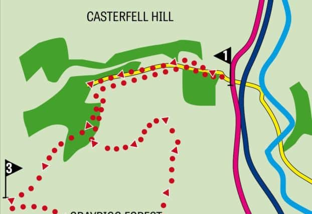
1. Once kitted up go through the metal gate and continue along the lane for well over half a mile with Borrowdale Beck to your right heading west. After an enclosed plantation turn left on something of a track that climbs up the fell towards a scattered stand of pine heading south and soon with a wall on the left. 500yds from the valley bottom cross a wall on the left at a junction – this might prove an awkward clamber and once over it head east with a wall on your left. This section of the walk is absent of footpaths as such and soon dips towards a small beck before swinging south (right) still hugging the wall as a handrail taking you over the rise of Birk Knott. From here you are treated with a surprising view of the escarpment with the first objective – Grayrigg Pike at the end of it. You might wonder as I did why isn’t this attractive piece of upland better known? The way is clear as a more definite path leads you to a depression below the Pike. Bagging it entails locating a gap in the wall and then traversing 600yds of moorland to reach the summit cairn. The view is....all the usual superlatives apply! In particular you are treated with a bird’s eye vision of the M6 almost 1000ft below. Looking north west the next objective is in sight – the trig point on top of Grayrigg Forest (there is no forest as such – presumably the name is used in an archaic sense meaning hunting ground). Retrace your steps to the gap in the wall and aim in the direction of the trig point.
2. This is a little visited top – not just by Lake District standards, by any standards - yet the next part of the walk quickly brings you back into contact with modern civilisation as you continue along the wide ridge towards a radio transmitting mast. While the path may not be defined the direction is clear as the way dips to a wall with stone stile and then intercepts the tarmac drive beyond the mast. Follow this down to a second mast – a repeater station.
3. The final part of the walk returns you to Borrowdale Valley. At the perimeter fence of the second mast turn around and bear left on something of a track which is in fact a bridleway that slants away from the ridge to reach a gate over 500yds later. Through this the bridleway decides to become clearer as it descends to the scattering of pines noticed near the start of the walk. Where the track divides bear right and soon return to your outward route.
- Walk devised by Malcolm McCulloch.
- Bob’s walks are now available as digital guides on the iFootpath website and App (see iFootpath.com).