Weekend walk: Clitheroe Town & Country


Here’s a walk that combines a long distance path with a fascinating town trail.
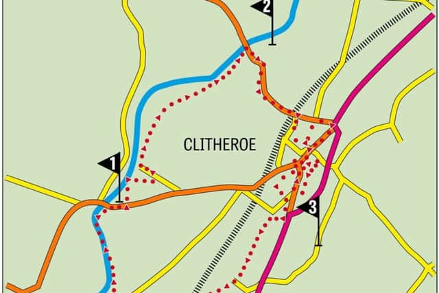
WALK FACTS
Start: Public car park opposite Roefield Leisure Centre BB7 3LA
Distance: 5 miles
Time: 2 – 3 hours
Grade: Easy
Maps: OS OL41 The Forest of Bowland
DIRECTIONS
Advertisement
Hide AdAdvertisement
Hide Ad1.From the car park cross Edisford Road to the entrance of the leisure centre to join the Ribble Way. This leads between the tennis centre and the pool to bring you to open ground as yet not built on. After making brief contact with the River Ribble turn away from it aiming towards a children’s playground. This deviation will bring you onto the main street of the (once) industrial community of Low Moor close to its imposing red brick built club. Turn left. Low Moor developed as a mill village in the late 18th and early 19th centuries. Many of the original houses can still be seen. Follow the road as in bends right and continues into Chapel Close where there has been much recent development. The road gives way to a broad farm track. Follow this to reach a kissing gate close to stables. Through this keep right to cross a rise and then join the Ribble Greenway overlooking an impressive weir and with a fine view of Waddow Hall the National Girl Guides Centre on the opposite side of the river. Follow the path down to river level and keep on the path to arrive at Brungerley Bridge.
2. Turn right onto Waddington Road which leads up into Clitheroe. Passing under the railway bridge soon after reach the junction with the descriptively named Railway View Road. Here turn right and soon after bear left onto Railway View Avenue. From this point on you are on a town trail taking in a number of historical buildings of interest. What follows is Nigel’s suggested route which is recommended if time allows. If the reader needs to cut it short or becomes confused head for the castle which dominates the town. Follow Railway View Street to join King Street bearing left climbing up the Market Place. To the right Castle Street – to the left Church Street. On the corner a particularly striking public library built in 1905 through the Carnegie Foundation. Walk up Church Street to the imposing St Mary Magdalene C of E parish church. It is often open to the public and is worth a browse. Continue along Church Brow to the junction with Waddington Road. Note on the corner close to a bus shelter is one of three wells that use to supply the town with drinking water. Follow the road right past Clitheroe Royal Grammar School into York Street home of the Grand Theatre which is the main venue for the Ribble Valley Jazz Festival. Back at the library turn left into Wellgate where in front of the Dog pub (Clitheroe’s oldest) a second ancient well can be viewed. Opposite turn right onto Lowergate. On reaching a public car park turn right through it following signs for the town centre via the Swan Courtyard. The Swan and Royal has an impressive list of past guests including Sir Winston Churchill, Gandhi, Sir Frank Whittle and Bob Clare! Turn left onto Castle Street and then 50 yds. along left again down a narrow passageway returning you to Lowergate car park. Turn right. The church of St Michael and St John’s RC church is worth visiting if open as it is adorned with very striking stained glass windows. As you arrive at the end of the street turn sharp right onto Moor Lane and climb up it to reach the entrance to the grounds of the castle opposite the junction with Castle Street.
3. The way climbs up below the castle mound and then a path on the left climbs more steeply still to the entrance to the keep. This structure is the second smallest of its type in England. A walkway above what might have been a moat happens to be one of Lancashire’s best viewing platforms with Pendle Hill dominating the valley to the east. Returning to the pathway that brought you to the keep go left through pleasant parkland (with open air theatre to you right). On reaching the bowling green go left and then on its far side turn right to reach the Woone Lane exit. Crossing the road bear left to and follow the side of Holmes Mill now the home of Bowland Brewery. This is reputed to have the longest continuous bar in Europe. For some reason I couldn’t manage to organise a serious drinking session there for the Dotcoms when we checked out this route. After passing the food hall keep ahead to Greenacre Street. Turn right and then at the next corner left onto Woone Lane.
4. Keep on Woone Lane for almost half a mile and when it bears left keep ahead on a track that leads past a new housing development and into an open space before a railway viaduct. Bear right on the main path passing below this and into fields with a brook to the right. In 500yds cross Henthorn Road re-joining the Ribble Way on a farm drive. Soon reunited with the river follow the path to Edisford Bridge. Turn right for the car park.
- Walk devised by Nigel Hext former Head of Physical Education, Barden High School, Burnley
- Bob’s walks are now available as digital guides on the iFootpath website and App (see iFootpath.com)