Weekend walk


For generations Nicky Nook has been a popular objective for walkers from Preston, Blackpool and Lancaster and places in between. Though not particularly high – 215m (705feet in old money!) – its relative isolation from the Bowland Fells to the east help to give it a wide panoramic view of the Fylde and Morecambe Bay. Most visitors ascend it from Scorton or from Higher Lane at the junction of Snowhill Lane. While this approach has the merit of being direct it is also steep. Here I suggest a route that tackles the fell from behind starting at Grizedale Bridge which is altogether easier. But of course there is a snag – locating Grizedale Bridge which is in a somewhat out of the way location.
WALK FACTS
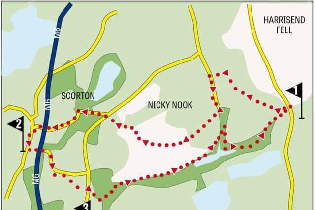
Start/finish: Grizedale Bridge PR3 1UJ (nearest) GR: SD536490. The key to finding Grizedale Bridge is to find the village of Oakenclough (PR3 1TB). As you arrive on Strickens Lane turn left onto the fell road. Grizedale Bridge is a mile further along.
Distance: 6 miles
Time: 2½ - 3 ½ hours
Advertisement
Hide AdAdvertisement
Hide AdGrade: The merit of the route is that it ascends Nicky Nook from its least steep side making it a moderate walk rather than a strenuous one.
Map: OL 41 Forest of Bowland
DIRECTIONS
1.Take the gravelly footpath leading west from the car park past the memorial shelter (dedicated to Sue Morris). After passing through a pair of wooden gates turn right in the direction of Fell End Farm. On a grassy bridleway cross a rise to another wooden gate and then descend towards Fell End Farm an extensive cluster of buildings. After a gate in a tree studded fence turn right and follow the path across two large pastures to the left of a corrugated metal barn to arrive on the drive of the farm. Turn left. In 250yds the drive reaches a tarmac lane end. Turn left through a metal gate on a well-made track. After a second metal gate look for a wooden kissing gate on the right hand side ¼ mile from the start of this track. At first there is a defined track to follow part way up the hill side. After this disappears continue climbing towards a tall stone pillar (purpose unknown – readers help!). From here the way is clear to the trig point crossing a broad plateau to a metal gate in the wall and then follow the grassy track to the summit. Admire the superlative view. From the trig point keep ahead to a wall corner and then angle right passing The Tarn over to your right to pick up a well-made gravel track that will take you downhill past a small reservoir to Higher Lane. On a junction keep ahead into Snowhill Lane and follow this as it takes you into the wooded surrounds of the Wyresdale Estate and across the motorway into Scorton.
2. This village is a popular destination for walkers, cyclists and day trippers. Turn left onto the main street and follow it past the parish church on the left and the bowling club. Turn left into Tithebarn Lane pass beneath the motorway and keep on the lane as it climbs uphill and then bends to the left. Past the bend look for a metal kissing gate on the right. Through this bear slightly left to another gate in a fence to the right of a corner. Still climbing cross the next field to Higher Lane. When you reach it turn right.
3. After passing Avon Nook keep ahead to where the lane bends right. Here go straight to a wooden gate onto a footpath that passes through trees to emerge onto a meadow and then intercepts a bridleway at a metal gate. Turn left through the gate to enter the lovely valley of Grize Dale. A broad track follows the valley bottom rising almost imperceptibly to the end of Grizedale Dock Reservoir in 3/4 mile. Keep on the track until you come to a wooden kissing gate on the right with a directional post for Grizedale Bridge. Through this the permissive path follows the edge of two arms of the reservoir to enter Holme Wood. Doubtless after wet weather this is a damp and boggy place but there are a number of causeways to assist you to go through it. As you reach the end climb a flight of steps taking you into the rough pastureland close to the car park.
- Bob’s walks are now available as digital guides on the iFootpath website and App (see iFootpath.com).