For some outdoor family adventures, Brimham rocks


As we reach the latter part of the school summer holidays here is a suggestion for an outing with your kids/grandkids. Take them to Brimham Rocks in the Nidderdale Area of Outstanding Natural Beauty. These amazing rock formations scattered across an upland moor offer immediate adventure to young and old alike. Wind, rain and ice have sculpted them into weird shapes creating a natural playground. The walk described below offers one way of seeing them with a circular route from Pateley Bridge but for readers desperate to distract energetic children before they return to school check out the National Trust website for details.
WALK FACTS
Start: Pateley Bridge South car Park – Nidderdale Show Ground HG3 5BD
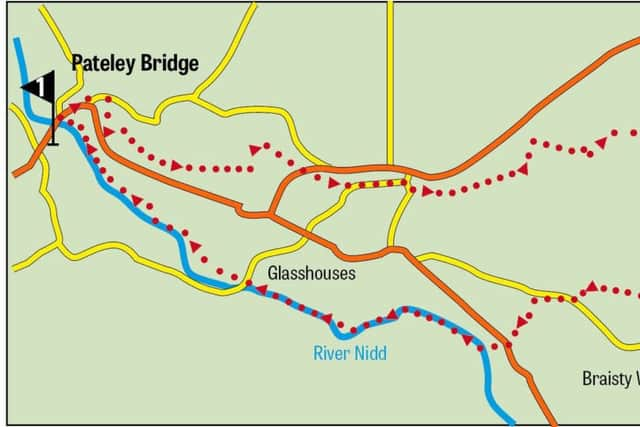
Distance: 8½ miles
Time: 4-5 hours
Advertisement
Hide AdAdvertisement
Hide AdGrade: Overall easy but with a sustained but not overly steep climb to Brimham Rocks and a couple of short steep climbs on the Nidderdale Way
Map: OS Explorer 298 Nidderdale
DIRECTIONS
1. Turn right from the car park cross the River Nidd and on the far side of the eponymous bridge turn right onto the riverside footpath. After passing through a residential area on what you will discover was the route of a railway line keep to the riverside on a pleasant wooded path as it follows the Nidd downstream to the next settlement of Glasshouses the inhabitants of which have never been known to throw stones. The approach to the village is heralded by a large artificial lake created for a mill in the early 19th century. On reaching a lane turn right cross the bridge and turn left onto a footpath on the far side. Keep on this path for a mile as it takes you past a sewerage works and then beneath a remnant rail bridge. A little under ¼ mile further on cross a high wooden footbridge and turn right negotiating a less even path than encountered so far. As this meets Fell Beck a feeder stream turn left to a footbridge and then after crossing it follow a footpath leading across a field on the edge of the village of Low Laithe. Cross the B6165 onto a bridleway that passes below an interesting house on the hillside (a converted chapel?). Keep on the track as it leads through a patch of woodland and past cottages to a scattered settlement called Smelthouses. Turn right on the lane and continue uphill for 300yds before turning left onto a bridleway at the side of a large stone built farmhouse. After passing by more cottages including “Artist’s Retreat” turn right as the way forks towards Brimham rather than Brimham Rocks. Keep on the track as it leads gently uphill for the best part of ¾ mile to reach the fell road on the edge of Brimham Moor. Turn left. In ¼ mile arrive at the entrance to the car park for the National Trust property of Brimham Rocks.
2. An obvious tourist track weaves its way through the extensive outcrop of millstone grit blocks taking you to an information centre and shop. Behind the information centre on a rise is a trig point. Climbing up to it offers a good view over the area – one slightly impeded by the roof of the information centre. To return to Pateley Bridge the idea is to follow the Nidderdale Way which presents two snags. First locating it and then once having found it managing to stay on it. From the information centre drop down to the main tourist path and go right (retracing your approach) and keep right between two imposing outcrops to descend on a path leading gently downhill into woodland. When this reaches a farm track turn right and follow it to Druids Cave Farm. Continue on the track passing the complex on your left. Before you reach the next farm turn right on a footpath that follows a wall on the boundary of the National Trust Property to reach High North Pasture Farm. Here the route becomes intricate. Cross a stile onto a drive and turn left towards farm buildings before turning right following a directional sign down towards the farmhouse. Passing the house on your right turn left through a metal gate into the first field and cross to a wooden stile on the far side. From here commence a long descent – almost ½ mile to wooded Fell Beck. Cross the stream by ford or footbridge and immediately join the Nidderdale Way turning left onto it close to Mill House. In theory this will lead you all the way back to Pateley Bridge but do not dispense with the map as it will be needed at two or three crucial junctions where the trial is not obviously marked. On the plus side once you’ve climbed up to Whitehouses close to the B6265 you are rewarded with high level panorama over a particularly beautiful valley.