A hidden tranquility amid the industrial '˜depotscape'


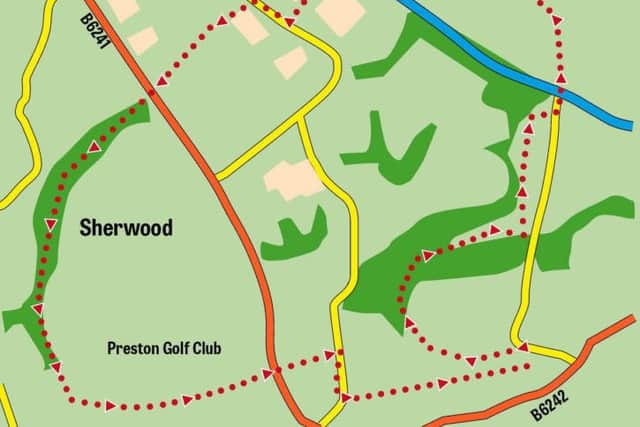
Earlier this year Lancashire Post reader John Hargreaves contacted me with details and description of an interesting route he found in the Fulwood area of Preston. “The Woodland Trust have worked wonders with some of the paths,” he wrote. Looking at the map I became intrigued as quite a portion of route seemed to pass through the depotscape of north Preston where industrial and commercial units have spawned in recent years on either side of the Guild Wheel the 21 mile cycleway that encircles the city. On a wet morning at the end of April I set out from the Anderton Arms to follow the route John sent me. It was a revelation even though I was familiar with most sections of it. As John had pointed out footpath and amenity improvements carried out by the Woodland Trust have helped create a rural walk in the middle of a suburb. So in thanking John for sharing his route with me I publish it below for others to enjoy. WALK FACTS
Start/finish: The Anderton Arms, Longsands Lane, Fulwood PR2 9PS. Note: If you do not intend using the Anderton Arms for refreshments after the walk there is plenty of nearby parking close to local shops.
Distance: 3½ miles
Time: 2–2½ hours
Grade: Easy
Map: OS Explorer 286 Blackpool & Preston
DIRECTIONS
Advertisement
Hide AdAdvertisement
Hide AdExit car park and turn left down Longsands Lane to bus stop. Cross over the road and take path near post box through trees.
Turn right to join Guild Wheel for 120yds then turn left to footbridge over Savick Brook and through Hindley Hill Woods and Midgery Wood to join Fernyhalgh Lane near the motorway.
Under the M6 to take track uphill past Ladyewell House, with, if time permitting, a short stop to see St Mary’s Well and shrine.
After 150yds leave the lane at right angle bend and go over the stile on left to take track alongside field towards M6 (some puddles). Over M6 footbridge through wood to turn right along Pittman Way for 200yds.
Advertisement
Hide AdAdvertisement
Hide AdImmediately before electricity substation turn left through wood to cross Midgery Lane, then across Caxton Road, and across Eastway at traffic light controlled crossing.
Through gate and immediately turn left down the track recently resurfaced by the Woodland Trust alongside the stream through Mason’s Wood for half a mile or so.
Cross footbridge over Savick Brook and through iron gate on to Preston Golf Course. Keep to the Public Right of Way which runs close to the tree line between the 17th and 18th fairways.
After 600yds join graded path at the top of the hill, pass the green of the first hole, turn right for 10yds then left at Public Footpath fingerpost to join a 50yd long difficult and very muddy track to the steps down to Eastway.
Advertisement
Hide AdAdvertisement
Hide AdCross the busy road with care and climb up more steps to join the muddy path running alongside Fulwood Hall Hospital.
Turn right along Midgery Lane and then left along Longsands Lane back to the car park and a welcome snack at the Anderton Arms.
POINTS OF INTEREST
Ladyewell. This ancient Catholic shrine has been a place of pilgrimage and devotion since the 11th century. Despite its proximity to the roaring traffic of the M6 motorway the grounds seem to exude a calm peacefulness not easily accessed in our busy modern world. The shrine to Our Lady as Queen of Martyrs is located below the Chapel to the right of the gardens as you enter from the drive. Even if you are not a believer it would be hard not to be touched by the special atmosphere of this place.
The Woodland Trust. With over 500,000 members and supporters and more than 1,000 sites, covering over 26,000 hectares, all over UK the Trust protects and campaigns on behalf of this country’s woods, plants trees, and restores ancient woodland for the benefit of wildlife and people. Mason’s Wood comprises of mainly mature mixed broadleaf woodland and boasting a rich ground flora. Eight main entrances and a network of linear surfaced footpaths link this site to the surrounding open space and public footpath network. See www.woodlandtrust.org.uk for more information. - Note: After the golf course the route crosses Eastway which can be very busy at times. John has written to Lancashire County Council to inquire if a Pelican Crossing can be placed here but the Highways Inspectorate have rejected the suggestion on grounds of cost to a finite budget and the fact no one has been killed or injured there in the past 5 years. We would not ask any of our readers to fall into this category but if on completing the walk you agree with John that Eastway merits a pedestrian crossing at this location contact LCC through its website www.lancashire.gov.uk. following links to Highways and register a concern.
- Walk devised and described by John Hargreaves.