Easy ramble calms the nerves after a lesson in mountain rescue


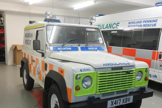
Last month the Lancashire Dotcom Walkers started off their walking year with a visit to the Bowland and Pennine Mountain Rescue Team’s depot near Garstang. There we enjoyed an informative morning with team members Ian Maddison and Paul Durham who talked to us about aspects of navigation and first aid. Ian’s presentation might be summarised how not to get lost and what can be done if you do. Paul’s talk covered trauma and medical emergency – the type of actions that might be taken until the mountain rescue team arrives. Accidents happen and they can happen at any time and anywhere. In upland areas such as the Forest of Bowland, far from immediate assistance, accidents move into an entirely different league of complexity. This is why the mountain rescue service came into being.
As more and more people devoted their leisure time to walking and climbing in the hills, previous almost ad hoc arrangements for searching and rescuing lost and injured people were found to be wanting. Between the wars the seeds of more formal organisation grew out of the various bodies connected with mountaineering, climbing, rambling and youth hosteling. In the more popular areas – Dungeon Ghyll in the Lake District and Glencoe in Scotland – unmanned mountain rescue posts were established where stretchers and first aid equipment were stored and maintained. In the post-war years mountain rescue teams were established covering all the upland areas of the country and funded through grants from the government supplemented by charitable donations. Specialist cave rescue teams were set up in areas covering the Yorkshire Dales and Derbyshire.
Advertisement
Hide AdAdvertisement
Hide AdThe teams are characterised by a high degree of professionalism even though they are composed entirely by volunteers. No matter how difficult an emergency becomes or how much time it takes to resolve it, team members like Ian and Paul will not receive payment. To become a team member they have already undergone a rigorous selection process followed by a rigorous training process and are required to give up chunks of what remains of their free time on training exercises, a number of which will take place during indisputably unsocial hours. All this so that they possess a high degree of preparedness when an emergency occurs.
As the Dotcoms finished their morning at Bowland and Pennine Mountain Rescue Team’s depot we were grateful not only for the illuminating presentations we were given but also knowing that should the worse happen in our walks in Lancashire and beyond we would be in very capable hands.
The walk described below is the route we took in the afternoon of our visit. I am pleased to report it was incident free. Readers wishing to donate to the BPMRT should go to its website www.bowlandpenninemrt.org.uk and follow the links.
Walk Facts
Start/Finish: Kenlis Arms PR3 1GD
Distance: 4 miles
Time: 2 – 3 hours
Grade: Very easy
Map: OS OL41 The Forest of Bowland
Directions
From the front of the pub turn right and keeping right under the railway bridge to cross the canal bridge. On its far side cross the road to access the tow path keeping left under the bridge. With the Lancaster Canal to your right walk along the tow path for 1 ¾ miles to reach the Wyre Aqueduct on the edge of Garstang. After admiring it from above descend a steep flight of steps just before it to admire it from below besides the River Wyre.
Advertisement
Hide AdAdvertisement
Hide AdNow on the Wyre Way pass under the aqueduct with the river on your left. After a pleasant wooded section pass through a converted corn mill to arrive on the B6430 Garstang Road. Cross slightly right into Castle Lane which leads past SS Mary & Michael Primary School to the ruins of Greenhalgh Castle 600yds further along. Keep straight entering Castle Close keeping right as the lane divides. Just before the metal gates of a house turn right onto an enclosed footpath. Follow this to a stile leading into open fields. With hedgerow to the right keep ahead to agricultural buildings. Cross a drive and take a waymark path crossing a field to a plank bridge stile.
There is a choice of paths here – yours is indicated by the waymark pointing straight ahead. Keeping to the edge of the field follow it to a metal gate directly below electricity cables. Through this cross the next field to a stile in hedgerow and then bearing left aim for the railway footbridge now in sight. After a metal gate join a track crossing first the railway and then the M6 motorway arrive at Bailton’s Farm. Keep ahead on a track with the farm to your right. Once leaving its complex walk 100yds and then take a footpath on the right (close to a dead tree). As you join a fence continue to a stile and keeping straight traverse two more fields to reach Sandholme Lane, close to Lees Farm. (As you cross the final stile onto the lane exercise extreme care and listen out for traffic as there is the risk you could be steeping into it.) Turn right and keep right at the next junction as the lane takes you back over the M6 to your starting point.
- Walk checked out by Frank Clare and described by his granddad Bob Clare