Lancashire weather forecast as Storm Debi weather warning raised to amber
and live on Freeview channel 276
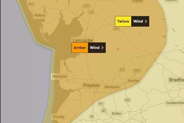
An amber weather warning is in place for the whole of Lancashire from 10am until 4pm, with forecasters expecting Storm Debi to unleash heavy rain and ‘disruptive winds’ over a 6-hour period.
The Met Office has warned of disruption to traffic and travel, with some rail journeys likely to be cancelled and roads closed due to inland gales of up to 65mph.
Advertisement
Hide AdAdvertisement
Hide AdThose living or visiting coastal areas are also urged to be vigilant as the Met Office warns of gusts of up to 80mph along the Fylde Coast.

“Injuries and danger to life is likely from large waves and beach material being thrown onto coastal roads, sea fronts and properties”, warns the forecaster.
It added there is also a chance that power cuts may occur, with the potential to affect other services, such as mobile phone coverage.
Flying debris is also a risk and could lead to injuries if the storm causes damage to buildings, such as tiles blown from roofs.
Advertisement
Hide AdAdvertisement
Hide AdThe wind is expected to ease after 4pm with Storm Debi to move into the North Sea by Monday evening.
Mini forecast
The Met Office says: “A spell of very strong westerly winds is expected to develop later Monday morning across northwest England in association with Storm Debi.
"Inland gusts of 60-65 mph are likely in places whilst along the coast gusts of 70-80 mph are expected. Winds will gradually ease into the evening.”
Hour-by-hour forecast
9am – 10% chance of rain, 11°, wind gusts 34mph
10am – 10% chance of rain, 11°, wind gusts 43mph
11am – 80% chance of rain, 10°, wind gusts 48mph
12pm – 80% chance of rain, 10°, wind gusts 54mph
1pm – 50% chance of rain, 11°, wind gusts 58mph
2pm – 60% chance of rain, 11°, wind gusts 62mph
3pm – 80% chance of rain, 11°, wind gusts 56mph
4pm – 10% chance of rain, 11°, wind gusts 52mph
5pm – 10% chance of rain, 11°, wind gusts 46mph
6pm – 10% chance of rain, 11°, wind gusts 39mph
7pm – 30% chance of rain, 11°, wind gusts 37mph
8pm – 10% chance of rain, 11°, wind gusts 33mph
9pm – 60% chance of rain, 11°, wind gusts 30mph
10pm – 60% chance of rain, 11°, wind gusts 29mph
11pm – 60% chance of rain, 11°, wind gusts 29mph
What to expect
- Flying debris is likely and could lead to injuries or danger to life
Advertisement
Hide AdAdvertisement
Hide Ad- Probably some damage to buildings, such as tiles blown from roofs
- Longer journey times and cancellations likely, as road, rail, air and ferry services are affected
- Some roads and bridges likely to close
- There is a good chance that power cuts may occur, with the potential to affect other services, such as mobile phone coverage
- Injuries and danger to life is likely from large waves and beach material being thrown onto coastal roads, sea fronts and properties