Hour-by-hour weather forecast for Preston after yellow thunderstorm warning issued by Met Office
and live on Freeview channel 276
Thunderstorms and torrential downpours may cause travel disruption and flooding in certain areas, the Met Office warned on Thursday (June 23).
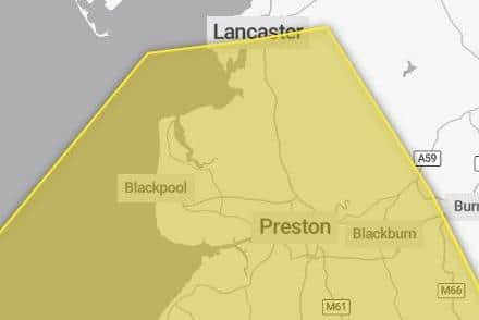
The yellow thunderstorm warning was put in place from 10am and was expected to end at 11.59pm.
It covers most of Lancashire except from Burnley and Bacup.
Advertisement
Hide AdAdvertisement
Hide AdA spokesman for the Met Office said: “Thunderstorms are likely to break out in some areas, particularly during the afternoon and early evening.
“While most places will probably miss them, where thunderstorms do occur there is a chance that in a few places up to 40mm of rain could fall in an hour or so and 40 to 60mm could fall in two or three hours.
“These torrential downpours may be accompanied by frequent lightning, whilst gusty winds and hail may also affect a few places.”
Forecasters said the exact location of the thunderstorms would be hard to pinpoint, “so the warning area will be kept under review and updated if necessary.”


Advertisement
Hide AdAdvertisement
Hide AdThe warning came after a spell of sunny and warm weather graced the county, with temperatures reaching highs of around 29C across the country.
Here’s what to expect, according to the Met Office:
- There is a small chance that homes and businesses could be flooded quickly, with damage to some buildings from floodwater, lightning strikes, hail or strong winds
- There is a small chance of fast flowing or deep floodwater causing danger to life
- Where flooding or lightning strikes occur, there is a chance of delays and some cancellations to train and bus services
Advertisement
Hide AdAdvertisement
Hide Ad- Spray and sudden flooding could lead to difficult driving conditions and some road closures
- There is a slight chance that power cuts could occur and other services to some homes and businesses could be lost
- There is a small chance that some communities become cut off by flooded roads
This is the hour-by-hour forecast for Thursday, June 23:
3pm – 26C – Sunny – Less than 5% chance of rain
4pm – 26C – Cloudy – 10% chance of rain
5pm – 24C – Cloudy – 10% chance of rain
6pm – 22C – Light rain – 50% chance of rain
7pm – 22C – Cloudy – 20% chance of rain
8pm – 21C – Cloudy – 20% chance of rain
9pm – 20C – Cloudy – 10% chance of rain
10pm – 19C – Cloudy – 10% chance of rain
11pm – 8C – Cloudy – 10% chance of rain
12 midnight – 18C – Cloudy – 10% chance of rain
What is the weather forecast for the rest of the week?
Friday, June 24
A dry morning for many with some bright or sunny spells.
Scattered showers will develop later, these becoming heavy and possibly thundery by evening.
Not as warm as Thursday.
Maximum temperature 22C.
Outlook for Saturday (June 25) to Monday (June 27):
Changeable over the next few days with showers or longer spells of rain.
The showers will be heavy and thundery in places and will be accompanied by brisk southwesterly winds.