Snow storm: This is when snow is most likely to hit Lancashire in February
and live on Freeview channel 276
Forecasters are predicting the UK is set to be plunged into arctic conditions this February.
With talk of a dramatic 'wall' of snow from Norway dying down, various weather charts and maps do still suggest Britons will witness a wintery change over the coming weeks, with some saying it could hit as soon as next week.

What about Lancashire?
Advertisement
Hide AdAdvertisement
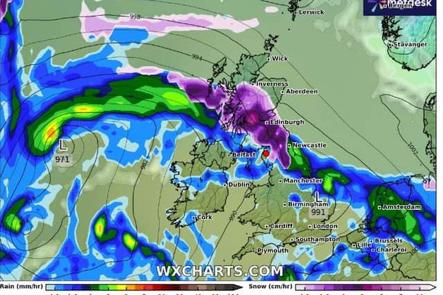
Hide AdNetWeather’s snow risk map showed much of Scotland, England and Wales could witness snow, and WX Charts maps show this could happen on Thursday, February 8. While on that day Lancashire looks to be rainy, according to Netweather, the red rose county could see snow and sleet a few days later, on February 10 and 11.
The BBC say: "Late next week there are signs that colder weather will make a return to the UK - so you'll probably need to get your big coat back on! Widespread frosts will return to the mornings and temperatures in the countryside could drop well below freezing, maybe even as low -10 Celsius for some next weekend.
"If you are hoping for snow, there is a much greater chance that some of you could see some late next week and possibly next weekend. At the moment, computer weather models are hinting that the greatest chance for seeing a covering of white could be in parts of northern England, Scotland and Northern Ireland, but it won't be everywhere."
What does the MET Office say?
According to the MET Office's long-range forecast from February 5 to 14, the North West is likely to see the heaviest and most frequent or most persistent rain, while the east, and especially southeast, will tend to be drier overall.
Advertisement
Hide AdAdvertisement
Hide AdExperts add: "There is a chance colder conditions could then start to feature slightly more widely during the second week of February, with increased chance of wintry weather across northern parts of the UK."
Comment Guidelines
National World encourages reader discussion on our stories. User feedback, insights and back-and-forth exchanges add a rich layer of context to reporting. Please review our Community Guidelines before commenting.