New look for part of Preston city centre as regeneration vision is unveiled
and live on Freeview channel 276
The 38-hectare site extends from the heart of the city centre around St. John’s Minister, out towards the Queens Retail Park in the east and Cardinal Newman College in the south – and also incorporates an area to the south east of the bus station.
Up to 1,600 homes could ultimately be built, along with new commercial properties – with the aim of also bringing back into use currently empty buildings which contribute to the character of the city, including the former Horrocks Mill.
Advertisement
Hide AdAdvertisement
Hide AdPreston City’s Council’s cabinet has adopted a so-called “supplementary planning document” (SPD), which outlines an overall vision for the area and could be afforded significant weight when it comes to deciding on individual planning applications.

The document does not in itself allocate any land for specific developments, but it does identify a number of “gaps” in the locality – in the form of vacant properties and street-level car parks – which it proposes are given over to more “beneficial uses”. Five out of the six sites earmarked in other planning policies for city centre housing fall within this area.
The SPD proposes a “significant improvement in environmental quality” around Stoneygate, describing large parts of the public realm in the area as “adequate at best”.
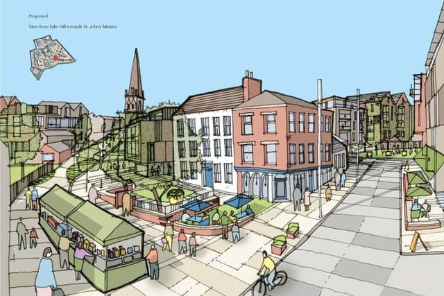
It lays out plans for a mixed-use development, with new buildings of various heights – but with the proviso that all significant views of the spire on the Minster are protected. There is also a focus on reducing “the dominance of traffic, whilst maintaining appropriate vehicle access”.
Advertisement
Hide AdAdvertisement
Hide AdThe document also reveals plans to expand Cardinal Newman College.
The city council’s cabinet member for planning and regeneration, Peter Moss, told a virtual meeting of the authority’s cabinet that responses to a consultation on the SPD earlier this year showed that the public was “really supportive” of the plans.
He added: “This is a long-term strategy – it’s very much indicative and will clearly evolve and change over time.”
The SPD describes the Stoneygate area as having “inherent potential due to its proximity to the heart of the city centre and has many of the factors that can make it…successful”.
Advertisement
Hide AdAdvertisement
Hide AdThe document identifies four “regeneration corridors” in the locality – Church Street, Manchester Road/Church Row, Queen Street and Stoneygate itself – but acknowledges that the envisaged changes will “not be realised overnight”. It also stresses that future developments should not be seen in isolation from each other.
WHAT IS BEING PLANNED WHERE?
The SPD describes four “character areas” and sets out how each of them should be encouraged to develop:
STONEYGATE
The Vision: “The area clearly has the potential to develop as a location of interest to creative industries, micro businesses and other entrepreneurs willing to take on older, in some cases unloved, buildings.”
The plans:
Landmark development next to Avenham car park
New commercial building with aspect to St. John’s Minster public space.
Enhanced space around St. John’s Minster
Shepherd Street/Manchester Road development
New space off Queen Street/Manchester Road
Advertisement
Hide AdAdvertisement
Hide AdNew building adjacent to Arkwright House, designed to maintain and reveal views of the church.
PERCY STREET/CHURCH STREET
The vision: “In addition to a number of smaller regeneration opportunities, the area includes the important Church Row/Derby Street site, adjacent to the southern access ramp to the bus station multi-storey car park and on the key pedestrian route between the bus station and the Manchester Road corridor.”
The plans:
New route and vista between the bus station and Church Street
The site underneath the ramps has the potential to create a new urban space, considered a prime location for the public realm.
HORROCKS QUARTER/GRIMSHAW STREET
Advertisement
Hide AdAdvertisement
Hide AdThe vision: “The scale of the Horrocks Quarter opportunity and the limited number of ownerships involved offer the potential to bring forward a viable scheme at an early point in the regeneration of Stoneygate. Done in the right way, this would then act as a catalyst for the regeneration of the wider area. Whilst it is acknowledged that the core Horrocks Mill site is identified as being suitable for a range of town centre uses…[the SPD] considers in particular the scope for residential as the predominant use for development in the area.
The plans:
Allocated housing sites – Grimshaw Street/Queen Street/Manchester Road; former Byron Hotel, Grimshaw Street.
Blue Bell Pub – a new civic space as part of a mixed-use scheme
Back Grimshaw Street – a new linking route
Cotton Court – key landmark
Back of pavement development on Queen Street
Queens Retail Park
CARDINAL NEWMAN COLLEGE/QUEEN STREET
The vision: “The strategy will contribute significantly to better connecting this area to the heart of the city centre, to the benefit of community safety, improve access to facilities and public transport and [provide] enhanced profile and linkages to the college. Current projections indicate an increase in demand for places at the college. In order to meet this, the college is looking to expand, either by extension of existing accommodation and/or the construction of new buildings.”
The plans:
Advertisement
Hide AdAdvertisement
Hide AdOpportunities should be taken to reduce traffic flow on Queen Street.
Any development should relate better to Queen Street, contributing to the change in character
Cardinal Newman College – expand teaching space, improve the visibility of the college and enhance the pedestrian connections to and throughout the area (particularly to the bus station and city centre)
Improve housing stock
Source: Stoneygate Supplementary Planning Document