
Major concerns identified as new plan for 350 homes in this Lancashire town comes to light
A development of 350 homes is being planned for agricultural land on the egde of a Lancashire town.
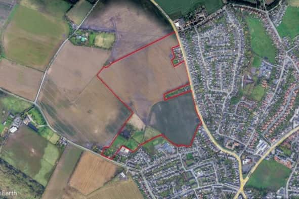
The proposal has come to light because Cheshire-based Gladman Developments Ltd has submitted a Scoping Report to West Lancashire Borough Council for 17.97 hectares (ha) of land off Southport Road, Ormskirk.
The land is close to residential properties, Ormskirk Asmall Primary School and Grade II-listed Aughton Hall.
A Scoping Report determines the breadth and focus of the issues that need to be considered during the planning process. It includes establishing the social, economic, and environmental characteristics of the area and looks at issues such as housing need.
What does the report say?
The report has raised several important issues that need investigating before a planning application for the homes is made - including potential contamination of the land, the development’s affect on heritage assets, and the impact on wildlife.
Contamination
The report states that the site is “wholly located within a Nitrate Vulnerable Zone 2017 Designation”. These are areas designated as being at risk from agricultural nitrate pollution and include about 55 per cent of land in England. The report goes on to say there is also a risk of contamination to ground during operation of the scheme and that recommended mitigation measures and an all “appropriate site investigations” will be undertaken to determine the current baseline contamination levels.
Wildlife
The site lies within a Countryside Stewardship Agreement Management area and has also been identified as an area of importance for the priority Lapwing bird species.
The report goes onto say that alhtough there are no statutory wildlife sites of local significance within 2 km of the site, there is a a ‘likely significant’ risk of a loss of foraging or roosting habitat for winter bird species associated with Martin Mere Special Protection Area (SPA)/Ramsar and/or Ribble and Alt Estuaries SPA/Ramsar as a result of direct habitat loss or disturbance impacts on nearby land.
Further detailed protected species surveys are proposed to be undertaken.
Heritage
The report states that an initial review suggests that the heritage significance of assets in the vicinity of the site may potentially be sensitive to residential development through changes in setting. They include
• The Grade II Listed White Rails Farmhouse and attached wall, and Grade II Listed Barn, to the south of the Site and east of the access.
• The Grade II Listed Aughton Hall, 80m to the south-west of the site, beyond Asmall Lane.
• The Grade II Listed Coach House at Asmall Hall.
An assessment will therefore be undertaken by Pegasus Group of the likely significant effects of the proposed development on the environment with respect to archaeology and built heritage.
Traffic
The report says that the proposed development “could affect traffic flows on the local highway network, which could increase the risk of transport accidents”, and as such, a Traffic and transport ES chapter will be undertaken which will consider highway safety, identifying measures to increase safety where necessary.

What we know about the proposed development
Very little detail about the housing plans have been released at this stage, but the report does that that the existing agricultural sheds and fencing, situated within the west of the site, wouild be demolished prior to construction of the proposed development and that access is proposed off Southport Road to the east, with a network of internal roads connecting the residential properties.
The developer also suggests a Proposed Open Space (POS) will be incorporated throughout the development, “with consideration to the retention, protection and enhancement of existing landscape and ecological features, with areas designated for Biodiversity Net Gain enhancement, and creation of green links across the site”.
There would be formal play areas, amenity areas for informal recreation, and a community orchard will also be incorporated in the POS. The existing pond on-Site will be retained to create a feature within the public open space and a landscape buffer will be formed along the northern and western boundary of the site, “to provide a transition to the surrounding rural countryside and softening the appearance of the proposed development”.
Additionally, they suggest there would be planting to the site boundaries to provide additional screening to views from surroundings public vantagepoints and residential properties. Homes located in the southeast area of the Site will have deeper rear gardens and will back onto the existing houses to ensure privacy and setting are respected.
West Lancashire Borough Council will make a decision on how to proceed in coming weeks.
For the latest public notices from your area, please visit: https://publicnoticeportal.uk/