
Housing plan for Green Belt dividing dozens in South Ribble village - here's what's proposed
More than 20 people have been moved to make representations over this application.
A plan for housing on Green Belt land in Whitestake is dividing the opinions of villagers.
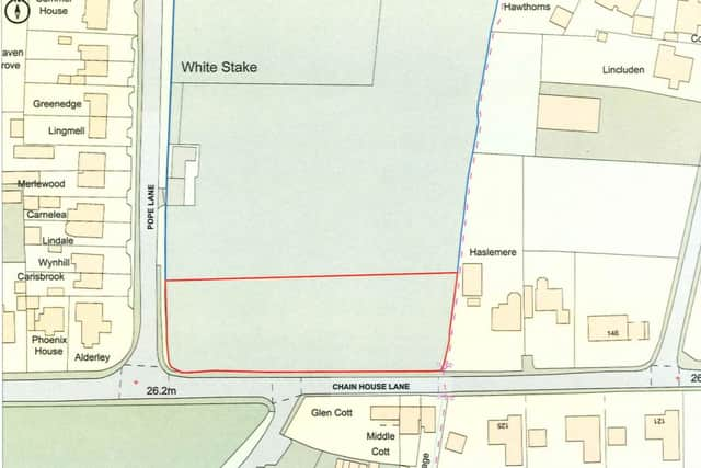
Laurie Russell has made a Permission in Principle application to construct up to four residential dwellinghouses on land fronting Chain House Lane, near Pope Lane and what is known as ‘Whitestake Corner’.
The 0.96 acre application site is located within the Green Belt and has long been used to graze horses.
Mr Russell’s agent argues that permission should be allowed because it is a village infill plot, and ‘satisfies the relevant requirments of local and national Green Belt planning policy’, and that a precedent has been set by allowing other similar scale residential developments nearby.
Objections
However, a number of locals disagree, and have sent their objections to South Ribble Borough Council. Many argue that the plot does not adequately satisfy the definition of infill development as it is not a limited void between an otherwise built up frontage, but is rather a large expanse of land, they note that the site regularly floods, and others have pointed out road safety concerns.
This stretch of road is where 15-year-old Dylan Crossey was fatally knocked off his bike in 2016, the junction with Long Moss Lane has historically been demarked with red asphalt as a hazard warning to drivers, and a SPID (speed indicator device) has been in place for some months, with locals concerned about frequent speeding.
Lancashire County Council (LCC) Highways have not objected, but have asked for criteria over entrance widths, visual splays and garage sizes to be met.
Others commented on the impact on the street scene and character of the village. One objector said: “This field provides an important physical and visual break between the settlements of Whitestake and New Longton. Development of this land would significantly reduce this separation and contribute towards the gradual coalescence of the two areas. The open land currently provides a clear distinction between the settlements, and once development is allowed to extend into this gap it would be extremely difficult to restore. Allowing housing on this site would therefore not simply affect one field; it could contribute towards the progressive joining together of Whitestake and New Longton and the loss of their individual identities.”

Support
A number of people have entered letters of support for the proposals, many stating that the existing field would look better with houses, and the development would boost the economy.
One letter said: “It would contibute to solving the flooding, provide in short term local jobs & income to the economy.”
Another said: “The area in question is normally flooded all winter and adds no aesthetic benefit. I support the application which will support to help and improve the local economy and also help the need to bring properties for local families to the village and surrounding area.”
Another said: “Over the last few years there have been many new properties built along Chain House Lane and I feel they have vastly improved the look of the area as they have been built to a high standard. I would have absolutely no objection to this proposed development.”
A decision will be made in coming weeks by planning bosses at SRBC.
For the latest public notices from your area, please visit: https://publicnoticeportal.uk/