Weekend Walk: Crooke


The motorway spans a wide valley with a wooded section of canal and railway close together in the natural corridor of the Douglas Valley. It is one of the more scenic views to be had south of the Lakes. This route will reverse that view putting you on the canal looking up at the fast moving traffic on the motorway.
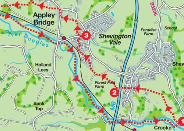
Directions: With the Leeds-Liverpool Canal on the left join a footpath that starts at the end of a terrace of houses. As this reaches open fields follow a broad track as it bends to the right and then reaches the edge of Ridges Wood. Keep on the track for a further 250yds until it comes to the modern housing development of Oakwood Meadows. Joining Vicarage Lane keep ahead at Gathurst Lane crossing to a public footpath between houses. When this reaches another road (Naylorfarm Ave) cross to a path that leads to a footbridge over the M6 motorway.
Advertisement
Hide AdAdvertisement
Hide AdOn the far side the footpath continues crossing Gathurst golf course on a waymarked route taking you to a kissing gate at a field corner. Through this follow the fence to the right to a gate. Beyond the gate turn left on a broad surfaced track and then right onto an enclosed path accessed by a wooden gate. This leads to the edge of a housing estate at Shevington Vale. Turn right on Broadriding Road and then after Knightscliffe Crescent on the left turn left onto a footpath between houses leading to open ground alongside the railway. Keep on the path to a junction. Turn right. The path leads onto a road and soon after reaches Mill Lane.
Turn left and after 150yds turn right onto a path following a stream through woodland. 250yds in turn left climbing up a rise where a strong metal fence denies any temptation to dive into the icy waters of East Quarry. When the track reaches a modern housing development follow the road to the left climbing an incline then turn left onto a track on the north side of the quarry. Keep on this to reach Appley Lane North. Turn right. Just before a road junction turn left onto a footpath by the corner of house number 104. The footpath leads across fields with a fine view of the Douglas Valley opening up to the left. At a drive turn right and then left resuming a westward direction. At the next lane continue straight across to a path leading into the Fairy Glen a well-known West Lancashire beauty spot famed for its bluebells especially at this time of year. The path leads down through trees, bear left and down to a footbridge and turn left to exit the woods at an awkward ladder stile. Resume the westwards direction across an open field. After another stile cross a large field with boundary on the left, to a stile leading into a green lane which can be extremely muddy after wet weather. This leads onto a broad farm track. After passing through a property turn left at the next junction on a track that crosses the railway and leads to the Leeds-Liverpool Canal.
Cross the bridge and with the placid waters of the canal on your left put away these directions and walk back to Crooke. You will get there… eventually. After a mile pass through the southern end of Appley Bridge. In a further 1 ½ miles arrive at the dramatic configuration of river, canal, railway and motorway.
Points of Interest: The Leeds-Liverpool Canal. The people of Wigan had to campaign vociferously to have the main route of the canal to pass through the town. With the opening up of the coalfields and the demand created by steam powered mills in Blackburn and Burnley, a diversion from the original route suddenly made sense. It wasn’t because they had a pier which needed water.
Advertisement
Hide AdAdvertisement
Hide AdFood and drink: The Crooke Hall Inn offers friendly service, real ale and excellent value. When Lancashire Dotcom walkers visited earlier this year it won high approval ratings.
l Walk devised by Stuart Holley and described by Bob Clare of www.lancashirewalks.com.
l Bob’s book “100 Walks in Lancashire” published by Crowood Press is now on sale.
__________________________
Start/finish: Crooke, near Wigan WN6 8LR
Distance: 13k, 8 miles
Time: 3½-4½ hours
Summary: Easy
Map: OS Explorer 285 Southport and Ormskirk