Straddling the counties on an excellent day's hiking


At the western edge of the Yorkshire Dales National Park there is a little known valley which is very different to its more visited neighbours. This is Kingsdale which is just four miles long, sparsely populated and has an elevation of over 800ft. It is a most intriguing place, lying between the bulky masses of Whernside and Great Coum. Because of its limestone character it is better known to cavers rather than walkers but there is much to interest the walker. The route described here provides an excellent day's hiking with the added attraction of reaching the highest summit entirely in Lancashire - the summit of Gragareth at 627m (2057’).
Walk Facts
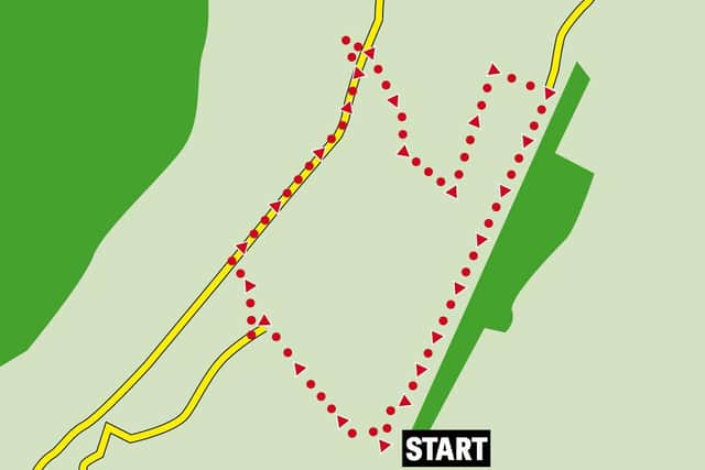
Start: From Thornton in Lonsdale, which is near the A65, a minor road - signposted to Dent - leads up to the valley. Soon after the top of the hill parking space is found on the left near the ruins of an old Lime kiln (ref 691757).
Distance: 8 miles
Time: 4 – 5 hours
Advertisement
Hide AdAdvertisement
Hide AdGrade: Challenging. Unless expert in navigation should not be attempted in mist.
Map: OS OL2 The Yorkshire Dales Western & Southern area
Directions
A broad track on the left leads up into the usual Dales landscape of white limestone outcrops amongst the lush green grass. Two detours from the main broad path are recommended. Firstly after the path passes between two limestone knolls it is worth ascending the left hand knoll to the trig point on Tow Scar where a kind clear day will give an impressive vista across Morecambe Bay to the Lakeland Heights with a possible sighting across to the Isle of Man. Return to the main path and where it begins to climb make a u-turn to the right, clamber through the stones and head east to find the Cheese Press Stone a 9’ high limestone erratic which provides the foreground to a fine view across to Ingleborough.
Go back to the main path, follow it for a few hundred yards you arrive at a junction of tracks. Turn left onto this track (marked The Turbary Road) and counter intuitively as the plan is to ascend Gragareth follow it downhill. The track doglegs right to reach a wall. On reaching a point where the wall on your right can be safely climbed cross the field diagonally towards a copse on a very faint path which passes close to a number of shake holes. A low stile on the edge of the copse will bring you to the entrance of Marble Steps Pot.
This hole is deep - 400’ - making it a Grade 3 hole. Searching for information online is difficult and leads only to incomprehensible caving jargon, some scary videos and a lot of adverts from bathroom sink salesmen. So walkers should pass by quickly.
Advertisement
Hide AdAdvertisement
Hide AdReturn to the stile, cross over and turn left around the head of the valley made by the stream that disappears down the pot. Continue uphill alongside the wall for a quarter of a mile until you intercept the ridge wall. Turn right and follow it upwards for a little over a mile. After the summit plateau is reached the wall bends slightly to the left and soon after a high stile is crossed. Climb over and follow the easy path leading northwards to reach the trig point which is the highest point entirely in Lancashire. Enjoy the wide view from Black Combe through the Lakes and Howgills to Ingleborough & the Bowland Hills.
Having taken in the view return to the wall and recross the stile. Now veer away from the wall on a southeasterly course on a pathless descent towards a wall on the right. Once off the very steepest bit head towards this wall and follow it down the hillside. Continue with the wall until reaching a small stream which flows through a gap in the wall and go through the gap with it. Climb a little away from the stream but continue to follow it down as the valley widens until it disappears underground. Its former course is clearly evident so stay with it until you find yourself at the edge of the Rowten Gill Pot which sits just across the Turbary Road which was crossed an hour or so ago. If Marble Steps was impressive this hole is even more so. Caused by the collapse of the roof of the underground stream.
Having examined the hole – carefully – return to the broad track and follow it through a gate heading heading north east. After crossing a second wall when the track begins to climb more steeply bear right and descend towards the valley road passing a couple of shake holes. On reaching the road turn left and soon come to the path leading to a clump of trees that marks the entrance to Yordas Cave.
Broad paths lead to the cave entrance and provided you have good watertight boots and a torch, going in is recommended. Once a Victorian show cave it now is patronised by school geography parties and discriminating walkers. Once inside you will here a small stream running gently from right to left and roaring water somewhere nearby. Adjust to the conditions and head up stream with a solid wall of rock to the right approaching the noise. A break in the rock wall appears and by leaning through you find yourself beneath the roaring water as an underground cataract plunges down. You may have wet feet by this time but you will have witnessed a most impressive and memorable sight. On emerging from the cave follow the path down to the road and a right turn will give you a long quiet walk back to the start.
- Walk devised and described by Malcolm McCulloch