Pulling a tractor along the River Wyre


The River Wyre is the longest river to flow entirely within Lancashire – it is about 28 miles in length.
It has two sources in the Bowland Fells; the Marshaw Wyre and the Tarnbrook Wyre. These two streams meet at Abbeystead. From here the river flows south to enter the Fylde through Dolphinholme, Garstang and Catterall. Here it is fed by the River Calder, which comes down from the fells above Oakenclough.
Advertisement
Hide AdAdvertisement
Hide AdAs the Wyre turns west near St Michaels it is joined by the River Brock. Also, it turns tidal. From Great Eccleston it winds its way across the Fylde before turning north to spill into Morecambe Bay at Fleetwood. It is claimed that the Wyre is the longest river in England whose estuary can be seen from its source – or at least one of its sources – the Tarnbrook branch.
The Wyre Way is a long distance path which, at 45 miles long, shadows rather than follows the river. This walk follows a large loop along the Wyre’s raised embankment close to the village of Great Eccleston.
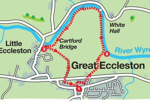
Start: Bus shelter centre of Great Eccleston opposite the White Bull. PR3 0ZB GR SD 427402
Directions: Cross High Street turn right and then almost immediately left on a side street that passes the public toilets. After 100yds turn right on to Back Lane. Keep on this to where it bends to the right. Turn left on a public footpath which leads down on a concrete track to the A586 Garstang Road. Cross with care to reach a wooden kissing gate to the right of a farm. Through this go through a metal gate almost opposite and bear right to the far corner of the field. Cross a stile and then following a fence on the right reach another stile before the embankment. Climb up the slope and join the river.
Advertisement
Hide AdAdvertisement
Hide AdTurn left. The route now follows a hairpin bend in the river as it sweeps round towards Cartford Bridge. After 600yds close to White Hall on the opposite bank the path passes a metal footbridge and pipeline. In another 1,000yds it draws close to Cartford Toll Bridge.
As the embankment ends and before reaching the Cartford Arms car park turn left over a small ladder stile.
Follow the path to a footbridge over a ditch and then continue to a stile in the right corner of the next field. This leads on to a farm track (Butt’s Lane). Keep on this past the large paddock to the right to reach Garstang Road. Cross with care and continue on Butt’s Lane to its junction with Back Lane. Turn left. In 200yds turn right to return to the start.
Points of Interest: Great Eccleston is a bustling village with a weekly market and an annual agricultural show. Featured in the show is the event of tractor pulling. The large paddock passed on Butt’s Lane is a purpose built arena for the North West Tractor Pulling Club (see www.nwtpc.co.uk ).
Advertisement
Hide AdAdvertisement
Hide AdCartford Toll Bridge. Unusual in that it is a toll bridge. For cars the rate is 40p.
Useful website www.visitwyre.co.uk for a map of the Wyre Way.
Where to eat and drink: The Courtyard Caffe (See www.thecourtyardcaffe.co.uk). Tel 01995 672011.
The White Bull Tel 01995 670203.
The Black Bull Tel 01995 670224.
The Cartford Inn ( see www.thecartfordinn.co.uk). Tel 01995 670116
Advertisement
Hide AdAdvertisement
Hide AdWalk devised by David Sherwood Johnstone secretary of the Norwest Fellwalking Club and described by Bob Clare. For more walks see www.lancashirewalks.com.
Distance: 2½ miles, 3.5k
Time: 1-1½ hours
Summary: Easy
Map: OS Explorer 296 Lancaster, Morecambe & Fleetwood