Take a brief(ish) encounter between railway stations...


Having consulted your Bradshaws here’s a walk that takes you from the world famous Carnforth Railway Station location of ‘Brief Encounter’ to Silverdale.
For this type of walk it is always best to have the rail journey completed first so parking at Silverdale is recommended if you are using the car.
DIRECTIONS
Advertisement
Hide AdAdvertisement
Hide Ad1. From Carnforth Railway Station cross the forecourt and turn left on to Warton Road. Keep on it as it passes below two railway bridges in quick succession and then after crossing the River Keer enters the settlement of Millhead.
Less than 100 yards from the river, turn right on to a drive way leading past cottages on the left. Keep on this as it brings you to pastures. Go through a wooden kissing gate and keep straight to another.
On the obvious track continue to a metal kissing gate leading into a residential area. Turn right.
At the end of the road turn left on a narrow path leading into open space close to the Malt Shovels pub. Turn right to reach the centre of Warton. Pass the church on the left and soon after the George Washington pub. Turn the next left on to Crag Road. This lane climbs steeply away from the village.
Advertisement
Hide AdAdvertisement
Hide AdAfter 200 yards turn right on to a footpath leading into Warton Crag local nature reserve. This area has a multiplicity of paths and it is easy to become confused especially in wooded sections.
Take the path at right angles to the road and at a junction 70 yards in turn left on to a broad rocky track that follows the edge of the escarpment to your left.
Keep on this for almost 600 yards to reach a fence and gate overlooking a car park. Pass through the gate and then take a narrow path on the right leading towards the highest part of the hill.T
his threads its way through and sometimes over limestone outcrops.
Advertisement
Hide AdAdvertisement
Hide AdWhere the path forks bear right and after a wooden stile scramble up a low cliff on to a broad grassy shelf. Again bear right when the path forks to arrive at the summit adorned with a trig point and a tall beacon.
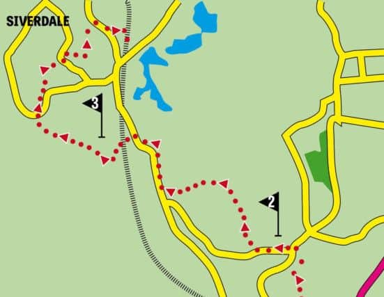
2.From the trig point take the path leading towards trees leading north (roughly the direction you’ve taken to reach the trig point).
There has been a great deal of woodland management here so once this would have taken you through trees but now it is cleared ground.
This drops gently over 600 yards to reach a bridleway. Go through a wooden gate and turn left.
Advertisement
Hide AdAdvertisement
Hide AdContinue the descent until you arrive back on Crag Lane in a little over ½ mile. Turn right. Keep on the lane to its junction with the Warton Road at Moss Farm.
Keep ahead on the road to the Silverdale sign and turn left along a broad track. After passing under the railway turn right to cross a channel following the Lancashire Coastal Way.
Now follow a raised embankment as it loops around fields to arrive at a crossroads of paths below Heald Brow.
3.The way here is up in the direction of Heald Brow and Hollins Lane.
Advertisement
Hide AdAdvertisement
Hide AdThe path climbs steeply to a wall entering National Trust land. Keep ahead coming open space and a wall.
Cross the wall by a stone stile and keep ahead across two large fields with a wall to your left. A small wooden gate lead to an enclosed path bringing you to Hollins Lane.
Turn right and immediately left on to a path into more National Trust property – Woodwell Cliff. Keep right following an upper path through trees.
When you reach open ground follow a signpost in the direction of the Green. This brings you to a fence enclosed path leading to a drive.
Advertisement
Hide AdAdvertisement
Hide AdAt the end of the drive turn right on a lane. Past a footpath sign and turn left at a junction into the Green that loops right to reach Bottoms Lane. Turn left.
Take the next footpath on the right and keep on the track to enter woodland.
Follow this as it bends left and arrives at Lamberts Meadow owned by guess who – got it in one the National Trust.
After entering the meadow cross a walkway on the right and passing through a gate entering more woods.
Advertisement
Hide AdAdvertisement
Hide AdThis climbs steeply at first and continues to the Row. Turn right and then take the next footpath on the left to cross Silverdale Golf Course.
Take all sensible precautions not to be hit by flying golf balls following the clearly marked path to Red Bridge Lane. Turn right for the station.
WALK FACTS
Start: Carnforth Railway Station LA5 9TR
Finish: Silverdale Railway Station
Distance: 6 miles/10k
Time: 2½-3½ hours
Grade: Moderate. There are two steep climbs. Readers be aware that the walk traverses limestone country and this can be hazardous when combined with mud - especially after rain when rocks become extremely greasy. I write this from painful experience.
Map: OS Ol 7 The English Lakes: South eastern area
- Walk devised by Steve Glover of the Lancashire Dotcom Walkers