Some superb views make Pleasington a pleasant spot


Most walks described in this column are circular assuming most readers will be able to use private transport to travel to the starting point. I tend to find linear walks psychologically more satisfying – that feeling of each step you take is bringing you closer to your objective providing you don’t get lost. Linear walks however rely on overcoming the logistical problem of returning to a start point once the walk is finished. This is where public transport can be a great help – especially bus routes. The 152 service links Preston with the East Lancashire towns of Blackburn and Burnley passing through a good deal of countryside on the way. Using the regular half hourly service will give you access to the delightful route described below.
WALK FACTS
Start: Hoghton Village Post Office, PR5 0DA
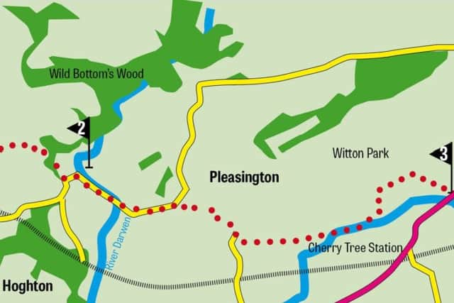
Finish: Witton Country Park BB2 2TP. For car users I suggest you park in the main car park of Witton Park and catch the 152 to Hoghton.
Distance: 5 miles
Time: 2-3 hours
Grade: Moderate. Mainly level with two inclines
Map: OS Explorer 287 The West pennine Moors
DIRECTIONS
Advertisement
Hide AdAdvertisement
Hide Ad1. From the post office walk along Hoghton Lane for a short distance to Quaker Brook Lane. Turn right. Passing through a pleasant residential area follow the lane as it gently descends to cross Quaker Brook and then turn right between a house and a riding paddock to join a green lane through a wooden gate. Keep on this track for a further ¼ mile to where it bends left and then 200yds later bends right taking you past a property on the left. Keep ahead on a less trodden path that soon brings you to a wooded lane leading onto Gib Lane. Turn right. Follow the road gently downhill for 250yds and then at a bend take a footpath on the left up a drive of a property called Sunnymeade. This soon brings you to fields. Keep ahead crossing two fields to a stile close to a corner. Cross this and then bear right to cross a large field diagonally in the direction of a stone footbridge over the railway. As you near it pass a pond on the right and then turn sharp left at a waymarked post. Keep to the hedge of the right and continue to a kissing gate. Cross this into a more open space. Keep ahead to pass through a gateway and continue to an enclosed patch of woodland. Cross a stile and follow the path as it turns right between trees and exits the wood at a stile and footbridge. Cross the next field to the hedge opposite and then turn right to follow a footpath sign through a scattering of farm buildings that is Highfield Farm. Its drive leads to a lane close to Bolton Hall (on your left). Cross the lane to a wooden stile and then following the line of telephone poles descend steeply down a wooded gully to reach a fence in front of fields. Turn left and follow the path leading to Hoghton Bottoms. After the first building keep left to arrive on a lane. Turn left passing between dwellings and after the last building on the left cross the river Darwen over a metal bridge.
2. This would make a pleasant picnic spot and as if to encourage you there is a picnic table overlooking the river. Turn right on a riverside path and follow it upstream for a little under ¼ mile to where it meets a farm track. Turn left following the track uphill to Higher Park Farm which has a superb view over the valley. As you near the building turn left onto its drive and follow it to reach a row of cottages and then a road at a bend. Now on tarmac for the next half mile keep ahead on the road as it descends to cross Trout Brook and then climbs up to Pleasington. Pass Pleasington Priory and immediately afterwards turn left on a footpath that leads down to the playing fields of Witton Park. Bear right to re-cross the River Darwen at Butler’s Bridge. Turn left and follow the riverside path to the next bridge. Cross this into the country park itself keeping to the path as it brings you (eventually) to the pavilion and running track.