A meander around Middle-earth


Close by Hurst Green the Ribble is joined by the Hodder and the Calder on a great bend of the river. Here, on this mid-section of the Ribble Way, walkers are given a wide prospect of the valley, with gentle walking. It is not difficult to imagine you are following in the footsteps of Gerald Manley Hopkins the Jesuit poet who was a master at nearby Stonyhurst College in the latter part of the 19th century. Much of his verse drew inspiration from the natural world and on this lovely reach you can feel especially close to it. This area has a more recent literary association. “Lord of the Rings” author J.R.R. Tolkien’s son attended Stonyhurst and it is documented that the landscape of the area provided Tolkien with a model for the Shire, home of his hobbit heroes Bilbo and Frodo Baggins. So do not be surprised should you spot an elf or a wizard and be especially careful not to upset an orc!
Walk Facts
Start: Hurst Green Village Centre BB7 9QJ
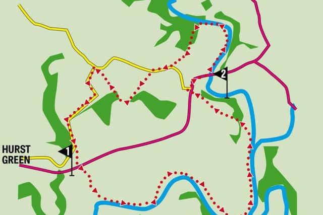
Distance: 7 miles
Time: 3-4 hours
Summary: Easy
Map: OS Explorer 287 West Pennine Moors
Directions
1. From the War Memorial cross the Longridge-Clitheroe Road (B6243) to the drive on the left of the Shireburn Arms. You have just joined the Ribble Way. Bear left on a track leading to a wooden gate – go through it and begin a long descent to the River Ribble. Keep to the right of the field and as the path crosses more open bear right across a gully (waymarked with a small pointer) and continue to a strip of woodland. After a stile the path edges along a field to a second stile that puts you in woods. Follow an obvious path left through woods and then after a footbridge and a stile reach the riverside meadows of the Ribble. With the river to your right walk upstream past the aqueduct bridge and then a fishing hut into the next field. Keep to the path as it edges alongside fields until you reach a tarmac drive near Jumbles. At this point note the feature marked as Jumble Rocks on the river – protruding rocks giving the Ribble a frisson of excitement. Pass the property on the left on a grassy path and then pick up another drive. Just after a utility building turn right through a gap with a defunct stile. With an open view Hacking Hall on the opposite bank will be seen ahead. It is claimed that this served as the inspiration for Brandywine Hall in “Lord of the Rings”. Just beyond it the River Calder spills its waters into the Ribble. You hang about for a confluence and two come along together because just over ½ a mile upstream the path meets the Hodder which can be seen through a gap in the trees. Continuing on a farm track the route arrives at Winckley Hall Farm. Turn right at the farmhouse to join a wooded drive climbing alongside Winckley Hall on the left. As the drive levels off take a footpath on the right that crosses four fields to reach the B6243 opposite a solidly constructed bus shelter. Turn right and walk down to the Lower Hodder Bridge.
Advertisement
Hide AdAdvertisement
Hide Ad2. Although the next part of the walk crosses the road just before the bridge to continue along the Hodder it is worth having a look at the old bridge from the middle of the one you are on. So called “Cromwell’s Bridge” the arched ruin downstream is of a vintage that makes it certain Cromwell’s army crossed it on the way to force battle at Preston in 1648 with Royalist forces. Cromwell’s decisive victory more or less brought an end to the English Civil war. Taking the footpath on the left of the road immediately before the bridge takes you along the delightful Hodder on a very attractive reach – especially at this time of year when autumn colours predominate. After the path enters woods at a gate and sewage works climb to the top of the rise and turn left on a footpath in the direction of “The defibrillator”! As you pass between buildings you’ll see this feature on the right and be assured you are on a public right of way. After passing Hodder Place keep ahead on the drive until you reach a lane. Turn right. After 200yds turn left on a cinder track into the grounds of Stonyhurst College. With playing fields to the right keep ahead for 600yds and after passing between agricultural (or perhaps horticultural) buildings turn right at a junction which follows a perimeter wall of the main college. The right of way takes you past an observatory and the impressive chapel to cross in front of the even more impressive façade of what appears to be the main entrance. (Which in fact is to the right of the chapel) Keep ahead passing college buildings ancient and modern to exit the grounds at a wooded corner. Turn left on the lane and then first left on another which brings to back to …the college! But this time you are half way down the impressive drive. Keep on the drive as it passes between playing fields and then before a statue of Our Lady turns left for the village.
- Walk devised by David Johnstone, Secretary of the Norwest Fellwalking Club.