A ringing endorsement for a lovely walk


On the day we checked out this route Lancashire Dotcom Walkers were joined by Maureen’s sister Joyce and Joyce’s two grown-up children Gemma and Ian. Also Joyce’s grand-daughter Libby just 20 weeks old. As we gathered on the Riverside car park in Towneley Park Gemma was having to go to some lengths to keep Libby out of the rain but I could see that this was a practised routine. “I have never been to the Singing Ringing Tree,” Gemma informed me, “But we’ve been up Pendle a few times.” She then asked me how far it was. I guesstimated two miles. In fact it was nearer three. Later as we came to Crown Point I apologised “I feel I have sold you a false prospectus,” fearing I had badly disrupted Libby’s feeding routines and sleep. But Gemma was far from put out, “What a lovely walk – we’ve enjoyed it.” What about going back? “Oh I’ve arranged for my husband to pick us up here.” Much relieved I took the family photograph by the Singing Ringing Tree. I hope when Libby is my age say 70 years hence she will be able to enjoy the countryside as much as her mother and the rest of the Dotcoms did back in October.
Walk Facts
Start/finish: Riverside pay and display car park, Towneley Park BB11 3RQ
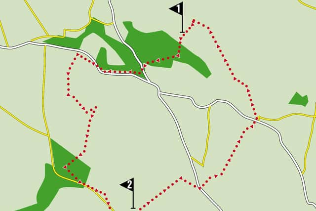
Distance: 6 miles
Time: 3 – 4 hours
Advertisement
Hide AdAdvertisement
Hide AdGrade: Moderate with a long but mainly gradual ascent to the Singing Ringing Tree
Maps: OS OL21 The South Pennines.
Directions
1. From the car park cross the River Calder on the bridge to its rear left and joining the main avenue walk up to Towneley Hall. The route keeps to the left of the main building, passes through the formal gardens joins Lime Walk and then continues to Foldy’s Cross. Here keep ahead to arrive on the Barwise entrance car park. Go through it to reach Todmodern Road (A6114). Turn right but soon after cross the road to a footpath signed as being on the Burnley Way. This climbs at first through trees and then on an enclosed path alongside open fields with a fine view towards Pendle Hill. Keep on it as it runs alongside the busy A646 heard but not seen just yet on the left. At a gate turn right and soon after cross to a drive and almost immediately after joining it take a footpath on the right that climbs steeply up an embankment and then continues fence enclosed to climb first to a drive and then to the perimeter of a golf course close to chain-link fenced reservoir. Go left edging along the course and following the corner right to arrive at a stile leading into rough pasture. Cross this negotiating mud, tussocks and awkward gullies until on firmer ground you overlook Copy Clough – a steep sided valley. Go left and then turn sharp right to reach the valley bottom opposite New Copy Farm. The next half mile of the route gives you a taste of almost wild country as you follow the clough up towards Crown Point Road. The path is always clear but can be very boggy after prolonged spells of wet weather. Be on the lookout for deer – they are frequently spotted in this area. After stiles, duckboards and footbridges the path levels out with superlative views behind. As you near the road be alert for a path on the left indicated by a shin height signpost. This takes you on a parallel course to the road but keeps you off it and brings you to Crown Point car park. The Singing Ringing Tree is reached by an enclosed path leading down from the rear of the car park.
2. In the opinion of this writer The Singing Ringing Tree is one of the finest pieces of public art in the country and ought to be as well-known as the Angel of the North. Constructed out of steel tubes, arranged in a way to resemble a windblown hawthorn tree and being hollow seem to “sing” or at least hum whenever the wind blows from whatever direction, it makes an emphatic statement on the landscape. From its enclosure cross a stile on the far side and follow a wall down to an awkward stile by a stone wall and gateway. Now with a wall to your left keep heading downhill to reach a gate leading onto the drive close to the garage of a property. Follow the drive down to the A671 Bacup Road. Cross the road and turn right. Soon after turn left onto a footpath that drops away steeply from the road. Keeping to the right of the field continue downhill to a stile leading onto a junction of tracks close a cluster of farm buildings. Cross the junction to pass through the yard of Dyneley Farm. As you enter fields on the far side keep left and left again to take a path through a metal gate and then bear right towards a brow with “the Fireman’s Helmet” wooded knoll to its right (note: helmet affect of this feature somewhat spoilt by the radio mast protruding from the trees). Through a gateway the path heads downhill to pass under the railway line and then continue to the A646 close to Walk Mill. Turn right and then left into Park Road. Follow until it brings you to a gate leading into a vast expanse of open space heralding Towneley Park.
- Walk devised by Edward Walton, Vice chair Burnley Civic Society